Fengjia geodata
Fengjia (Chongqing) is a seat of a fourth-order administrative division; located in China in Asia/Shanghai (GMT+8) time zone. In our database, there are 1268 cities with bigger population. Compared to other cities in China, 60.9% of cities are located further ↑North; 77.3% of cities are located further →East and 71.3% of cities have lower elevation than Fengjia. Note1


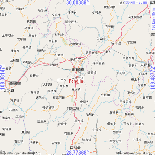
Fengjia GPS coordinates[2]
29° 23' 35.268" North, 108° 47' 4.524" East
| Map corner | latitude | longitude |
|---|---|---|
| Upper-left | 30.00389°, | 108.08147° |
| Center: | 29.39313°, | 108.78459° |
| Lower-right: | 28.77868°, | 109.48772° |
| Map W x H: | 136.2×136.2 km | = 84.6×84.6mi |
| max Lat: | 53.31946° ⇑60.9% North |
| Fengjia: | 29.39313° |
| min Lat: | ⇓39.1% South 18.22056° |
| min Long | Fengjia | max Long |
| 75.07348° | 108.78459° | 134.28917° |
| W 22.7%⇐ | ⇒77.3% E |
Elevation
Elevation of Fengjia is 436 m = 1430 ft, and this is 48.8 m = 160 ft below average elevation for this country.
| Max E: |
5622 m = 18445 ft | 28.7% |
| Avg. | 484.8 m = 1591 ft | |
| Fengjia | 436 m = 1430 ft | |
Min E: |
-3 m = -10 ft | 71.3% |
See also: China elevation on elevation.city.
Geographical zone
Fengjia is located in North temperate zone (between Tropic of Cancer and the Arctic Circle). Distance of this Northern Tropic circle is 662.3 km =411.5 mi to South.| Distance of | km | miles | from Fengjia |
|---|---|---|---|
| North Pole | 6738.9 | 4187.4 | to North |
| Arctic Circle | 4133 | 2568.1 | to North |
| Tropic Cancer | 662.3 | 411.5 | to South |
| Equator | 3268.2 | 2030.8 | to South |


Nearby cities:
15 places around Fengjia: (largest is in red/bold)
• Baitu
13.9 km =8.6 mi,  263°
263°
• Chengdong
14.7 km =9.1 mi,  0°
0°
• Chengnan
14.2 km =8.8 mi,  358°
358°
• Daji
13.8 km =8.6 mi,  239°
239°
• Jinxi
9.5 km =5.9 mi,  269°
269°
• Mala
13.8 km =8.6 mi,  152°
152°
• Pengdong
3.8 km =2.4 mi,  101°
101°
• Qianjiang
15.6 km =9.7 mi, 356°
• Shuishi
18.6 km =11.6 mi,  206°
206°
• Shuitian
4.8 km =3 mi,  280°
280°
• Wuli
9.6 km =6 mi,  113°
113°
• Xinhua
19.1 km =11.9 mi,  246°
246°
• Zhengyang
7.3 km =4.5 mi, 2°
• Zhoubai
15.6 km =9.7 mi,  13°
13°
• Zhuoshui
10.1 km =6.3 mi,  187°
187°
Sources, notices
• [Note1] Compared only with cities in China existing in our database
• [Src1] Map data: © OpenStreetMap contributors (CC-BY-SA)
• [Src2] Other city data from geonames.org with taken over terms of usage.
• [Src3] Geographical zone / Annual Mean Temperature by Robert A. Rohde @ Wikipedia
