Dougou geodata
Dougou (Jiangsu) is a seat of a fourth-order administrative division; located in China in Asia/Shanghai (GMT+8) time zone. In our database, there are 1268 cities with bigger population. Compared to other cities in China, 71.4% of cities are located further ↓South; 76.7% of cities are located further ←West and 92.7% of cities have higher elevation than Dougou. Note1


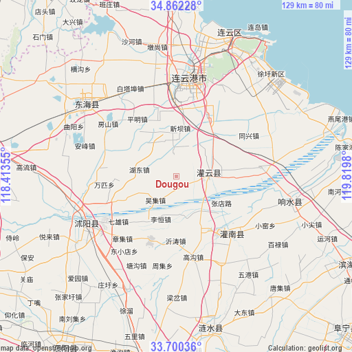
Dougou GPS coordinates[2]
34° 16' 59.988" North, 119° 7' 0.012" East
| Map corner | latitude | longitude |
|---|---|---|
| Upper-left | 34.86228°, | 118.41355° |
| Center: | 34.28333°, | 119.11667° |
| Lower-right: | 33.70036°, | 119.8198° |
| Map W x H: | 129.2×129.2 km | = 80.3×80.3mi |
| max Lat: | 53.31946° ⇑28.6% North |
| Dougou: | 34.28333° |
| min Lat: | ⇓71.4% South 18.22056° |
| min Long | Dougou | max Long |
| 75.07348° | 119.11667° | 134.28917° |
| W 76.7%⇐ | ⇒23.3% E |
Elevation
Elevation of Dougou is 8 m = 26 ft, and this is 476.8 m = 1564 ft below average elevation for this country.
| Max E: |
5622 m = 18445 ft | 92.7% |
| Avg. | 484.8 m = 1591 ft | |
| Dougou | 8 m = 26 ft | |
Min E: |
-3 m = -10 ft | 7.3% |
See also: China elevation on elevation.city.
Geographical zone
Dougou is located in North temperate zone (between Tropic of Cancer and the Arctic Circle). Distance of this Northern Tropic circle is 1206 km =749.4 mi to South.| Distance of | km | miles | from Dougou |
|---|---|---|---|
| North Pole | 6195.1 | 3849.5 | to North |
| Arctic Circle | 3589.2 | 2230.2 | to North |
| Tropic Cancer | 1206 | 749.4 | to South |
| Equator | 3811.9 | 2368.6 | to South |


Nearby cities:
15 places around Dougou: (largest is in red/bold)
• Baixian
20.4 km =12.7 mi,  76°
76°
• Gaoxu
11.4 km =7.1 mi,  299°
299°
• Liheng
17.8 km =11.1 mi,  200°
200°
• Liji
23.4 km =14.5 mi,  147°
147°
• Longju
9.4 km =5.8 mi,  350°
350°
• Mengxingzhuang
15.2 km =9.4 mi,  142°
142°
• Muxu
12.1 km =7.5 mi,  358°
358°
• Nangang
5.1 km =3.2 mi, 150°
• Tangjian
19.6 km =12.2 mi,  211°
211°
• Wuji
11.4 km =7.1 mi,  216°
216°
• Xiache
19.8 km =12.3 mi,  68°
68°
• Xinba
17.5 km =10.9 mi,  4°
4°
• Yishan
12.8 km =8 mi, 81°
• Yitao
22.3 km =13.9 mi,  183°
183°
• Zhangdian
19.2 km =11.9 mi,  118°
118°
Sources, notices
• [Note1] Compared only with cities in China existing in our database
• [Src1] Map data: © OpenStreetMap contributors (CC-BY-SA)
• [Src2] Other city data from geonames.org with taken over terms of usage.
• [Src3] Geographical zone / Annual Mean Temperature by Robert A. Rohde @ Wikipedia
