Donghu geodata
Donghu (Zhejiang) is a seat of a fourth-order administrative division; located in China in Asia/Shanghai (GMT+8) time zone. In our database, there are 1268 cities with bigger population. Compared to other cities in China, 53.7% of cities are located further ↑North; 85.7% of cities are located further ←West and 88.7% of cities have higher elevation than Donghu. Note1


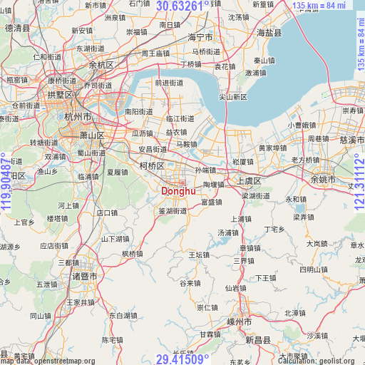
Donghu GPS coordinates[2]
30° 1' 32.592" North, 120° 36' 28.764" East
| Map corner | latitude | longitude |
|---|---|---|
| Upper-left | 30.63261°, | 119.90487° |
| Center: | 30.02572°, | 120.60799° |
| Lower-right: | 29.41509°, | 121.31112° |
| Map W x H: | 135.4×135.4 km | = 84.1×84.1mi |
| max Lat: | 53.31946° ⇑53.7% North |
| Donghu: | 30.02572° |
| min Lat: | ⇓46.3% South 18.22056° |
| min Long | Donghu | max Long |
| 75.07348° | 120.60799° | 134.28917° |
| W 85.7%⇐ | ⇒14.3% E |
Elevation
Elevation of Donghu is 11 m = 36 ft, and this is 473.8 m = 1554 ft below average elevation for this country.
| Max E: |
5622 m = 18445 ft | 88.7% |
| Avg. | 484.8 m = 1591 ft | |
| Donghu | 11 m = 36 ft | |
Min E: |
-3 m = -10 ft | 11.3% |
See also: China elevation on elevation.city.
Geographical zone
Donghu is located in North temperate zone (between Tropic of Cancer and the Arctic Circle). Distance of this Northern Tropic circle is 732.6 km =455.2 mi to South.| Distance of | km | miles | from Donghu |
|---|---|---|---|
| North Pole | 6668.5 | 4143.6 | to North |
| Arctic Circle | 4062.6 | 2524.4 | to North |
| Tropic Cancer | 732.6 | 455.2 | to South |
| Equator | 3338.5 | 2074.4 | to South |


Nearby cities:
15 places around Donghu: (largest is in red/bold)
• Chengnan
7.1 km =4.4 mi,  213°
213°
• Dongpu
8.1 km =5 mi,  294°
294°
• Doumen
8.1 km =5 mi,  349°
349°
• Fushan
5.6 km =3.5 mi,  236°
236°
• Fusheng
12.8 km =8 mi,  122°
122°
• Gaobu
5.7 km =3.5 mi,  108°
108°
• Jianhu
6.2 km =3.9 mi, 214°
• Jinsanjiao
8.8 km =5.5 mi, 242°
• Jishan
6.2 km =3.9 mi,  182°
182°
• Lingzhi
3.3 km =2.1 mi,  275°
275°
• Mashan
7.7 km =4.8 mi,  38°
38°
• Qixian
12.7 km =7.9 mi,  327°
327°
• Shaoxing
3.8 km =2.4 mi,  227°
227°
• Sunduan
9.8 km =6.1 mi,  60°
60°
• Taoyan
11.6 km =7.2 mi,  92°
92°
Sources, notices
• [Note1] Compared only with cities in China existing in our database
• [Src1] Map data: © OpenStreetMap contributors (CC-BY-SA)
• [Src2] Other city data from geonames.org with taken over terms of usage.
• [Src3] Geographical zone / Annual Mean Temperature by Robert A. Rohde @ Wikipedia
