Dong’ao geodata
Dong’ao (Hainan) is a seat of a fourth-order administrative division; located in China in Asia/Shanghai (GMT+8) time zone. In our database, there are 1268 cities with bigger population. Compared to other cities in China, 99.8% of cities are located further ↑North; 69.5% of cities are located further →East and 92.7% of cities have higher elevation than Dong’ao. Note1


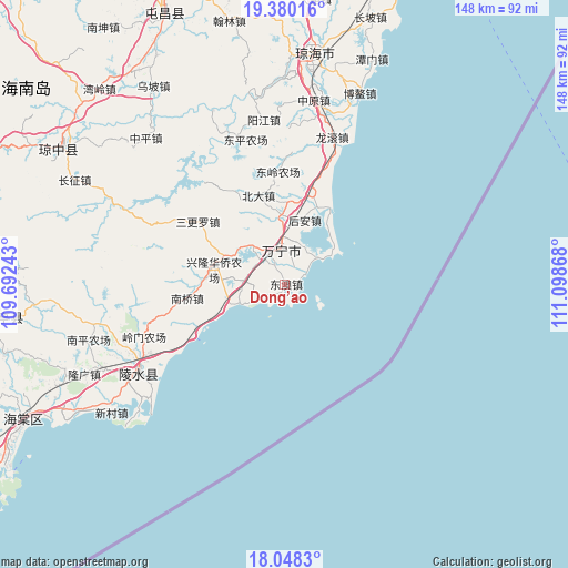
Dong’ao GPS coordinates[2]
18° 42' 55.944" North, 110° 23' 43.98" East
| Map corner | latitude | longitude |
|---|---|---|
| Upper-left | 19.38016°, | 109.69243° |
| Center: | 18.71554°, | 110.39555° |
| Lower-right: | 18.0483°, | 111.09868° |
| Map W x H: | 148.1×148.1 km | = 92×92mi |
| max Lat: | 53.31946° ⇑99.8% North |
| Dong’ao: | 18.71554° |
| min Lat: | ⇓0.2% South 18.22056° |
| min Long | Dong’ao | max Long |
| 75.07348° | 110.39555° | 134.28917° |
| W 30.5%⇐ | ⇒69.5% E |
Elevation
Elevation of Dong’ao is 8 m = 26 ft, and this is 476.8 m = 1564 ft below average elevation for this country.
| Max E: |
5622 m = 18445 ft | 92.7% |
| Avg. | 484.8 m = 1591 ft | |
| Dong’ao | 8 m = 26 ft | |
Min E: |
-3 m = -10 ft | 7.3% |
See also: China elevation on elevation.city.
Geographical zone
Dong’ao is located in North Torrid zone (between Equator and Tropic of Cancer). Distance of this Northern Tropic circle is 524.9 km =326.2 mi to North.| Distance of | km | miles | from Dong’ao |
|---|---|---|---|
| North Pole | 7926.1 | 4925 | to North |
| Arctic Circle | 5320.2 | 3305.8 | to North |
| Tropic Cancer | 524.9 | 326.2 | to North |
| Equator | 2081 | 1293.1 | to South |


Nearby cities:
15 places around Dong’ao: (largest is in red/bold)
• Beida
24.2 km =15 mi,  343°
343°
• Changfeng
13.4 km =8.3 mi,  316°
316°
• Damao
14.9 km =9.3 mi,  358°
358°
• Guangpo
40.6 km =25.2 mi,  243°
243°
• Hele
22.2 km =13.8 mi,  21°
21°
• Hou’an
17.7 km =11 mi, 17°
• Huishan
41.8 km =26 mi, 340°
• Liji
9.4 km =5.8 mi,  295°
295°
• Longgun
39.7 km =24.7 mi, 20°
• Nanqiao
27.1 km =16.8 mi,  260°
260°
• Sangengluo
28 km =17.4 mi,  305°
305°
• Shangen
29.7 km =18.5 mi, 17°
• Timeng
43 km =26.7 mi,  245°
245°
• Wanning
9.4 km =5.8 mi,  352°
352°
• Yangjiang
43.2 km =26.8 mi, 352°
Sources, notices
• [Note1] Compared only with cities in China existing in our database
• [Src1] Map data: © OpenStreetMap contributors (CC-BY-SA)
• [Src2] Other city data from geonames.org with taken over terms of usage.
• [Src3] Geographical zone / Annual Mean Temperature by Robert A. Rohde @ Wikipedia
