Dingzhou geodata
Dingzhou (Hebei) is a populated place; located in China in Asia/Shanghai (GMT+8) time zone. With population of 152,934 people, there are 289 cities with bigger population in this country. Compared to other cities in China, 81.8% of cities are located further ↓South; 54.3% of cities are located further ←West and 67.2% of cities have higher elevation than Dingzhou. Note1


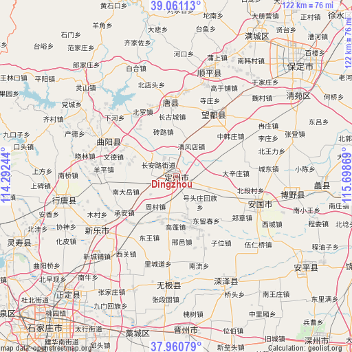
Dingzhou GPS coordinates[2]
38° 30' 47.016" North, 114° 59' 44.016" East
| Map corner | latitude | longitude |
|---|---|---|
| Upper-left | 39.06113°, | 114.29244° |
| Center: | 38.51306°, | 114.99556° |
| Lower-right: | 37.96079°, | 115.69869° |
| Map W x H: | 122.3×122.3 km | = 76×76mi |
| max Lat: | 53.31946° ⇑18.2% North |
| Dingzhou: | 38.51306° |
| min Lat: | ⇓81.8% South 18.22056° |
| min Long | Dingzhou | max Long |
| 75.07348° | 114.99556° | 134.28917° |
| W 54.3%⇐ | ⇒45.7% E |
Elevation
Elevation of Dingzhou is 64 m = 210 ft, and this is 420.8 m = 1381 ft below average elevation for this country.
| Max E: |
5622 m = 18445 ft | 67.2% |
| Avg. | 484.8 m = 1591 ft | |
| Dingzhou | 64 m = 210 ft | |
Min E: |
-3 m = -10 ft | 32.8% |
See also: Dingzhou elevation on elevation.city.
Geographical zone
Dingzhou is located in North temperate zone (between Tropic of Cancer and the Arctic Circle). Distance of this Northern Tropic circle is 1676.3 km =1041.6 mi to South.| Distance of | km | miles | from Dingzhou |
|---|---|---|---|
| North Pole | 5724.8 | 3557.2 | to North |
| Arctic Circle | 3118.9 | 1938 | to North |
| Tropic Cancer | 1676.3 | 1041.6 | to South |
| Equator | 4282.3 | 2660.9 | to South |


Nearby cities:
15 places around Dingzhou: (largest is in red/bold)
• Changgucheng
21.4 km =13.3 mi,  352°
352°
• Cheng’an
22.2 km =13.8 mi,  234°
234°
• Dicun
21.2 km =13.2 mi,  268°
268°
• Dongwang
15.2 km =9.4 mi,  302°
302°
• Dugu
17.3 km =10.7 mi,  221°
221°
• Gaopeng
17.7 km =11 mi,  180°
180°
• Mingyuedian
11.1 km =6.9 mi,  235°
235°
• Nandayue
18.3 km =11.4 mi,  256°
256°
• Pangcun
11.6 km =7.2 mi, 347°
• Wende
22.6 km =14 mi,  288°
288°
• Xiaoyoucun
13.7 km =8.5 mi,  250°
250°
• Yanzhao
17 km =10.6 mi,  284°
284°
• Zhaocun
8.8 km =5.5 mi, 303°
• Zhoucun
13 km =8.1 mi, 215°
• Zhuanlu
16.5 km =10.3 mi,  344°
344°
Sources, notices
• [Note1] Compared only with cities in China existing in our database
• [Src1] Map data: © OpenStreetMap contributors (CC-BY-SA)
• [Src2] Other city data from geonames.org with taken over terms of usage.
• [Src3] Geographical zone / Annual Mean Temperature by Robert A. Rohde @ Wikipedia
