Dayang geodata
Dayang (Fujian) is a seat of a fourth-order administrative division; located in China in Asia/Shanghai (GMT+8) time zone. In our database, there are 1268 cities with bigger population. Compared to other cities in China, 83.5% of cities are located further ↑North; 76.4% of cities are located further ←West and 65.9% of cities have lower elevation than Dayang. Note1


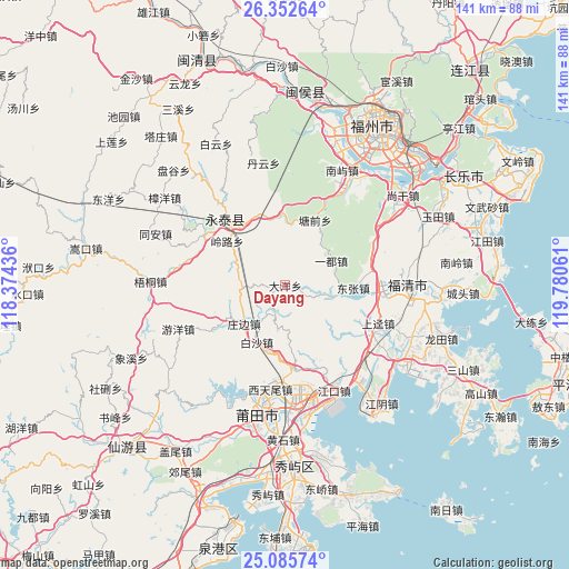
Dayang GPS coordinates[2]
25° 43' 15.168" North, 119° 4' 38.928" East
| Map corner | latitude | longitude |
|---|---|---|
| Upper-left | 26.35264°, | 118.37436° |
| Center: | 25.72088°, | 119.07748° |
| Lower-right: | 25.08574°, | 119.78061° |
| Map W x H: | 140.9×140.9 km | = 87.6×87.6mi |
| max Lat: | 53.31946° ⇑83.5% North |
| Dayang: | 25.72088° |
| min Lat: | ⇓16.5% South 18.22056° |
| min Long | Dayang | max Long |
| 75.07348° | 119.07748° | 134.28917° |
| W 76.4%⇐ | ⇒23.6% E |
Elevation
Elevation of Dayang is 342 m = 1122 ft, and this is 142.8 m = 469 ft below average elevation for this country.
| Max E: |
5622 m = 18445 ft | 34.1% |
| Avg. | 484.8 m = 1591 ft | |
| Dayang | 342 m = 1122 ft | |
Min E: |
-3 m = -10 ft | 65.9% |
See also: China elevation on elevation.city.
Geographical zone
Dayang is located in North temperate zone (between Tropic of Cancer and the Arctic Circle). Distance of this Northern Tropic circle is 254 km =157.8 mi to South.| Distance of | km | miles | from Dayang |
|---|---|---|---|
| North Pole | 7147.2 | 4441.1 | to North |
| Arctic Circle | 4541.3 | 2821.8 | to North |
| Tropic Cancer | 254 | 157.8 | to South |
| Equator | 2859.9 | 1777.1 | to South |


Nearby cities:
15 places around Dayang: (largest is in red/bold)
• Baisha
15.5 km =9.6 mi,  205°
205°
• Chengfeng
21.8 km =13.5 mi,  318°
318°
• Chixi
23.2 km =14.4 mi,  286°
286°
• Dongzhang
16.9 km =10.5 mi,  93°
93°
• Fuquan
23.6 km =14.7 mi,  304°
304°
• Geling
18 km =11.2 mi,  358°
358°
• Honglu
23.8 km =14.8 mi, 94°
• Linglu
18.4 km =11.4 mi,  307°
307°
• Qiulu
21.6 km =13.4 mi,  176°
176°
• Shangjing
24.7 km =15.3 mi,  111°
111°
• Tangqian
17.7 km =11 mi,  24°
24°
• Xinxian
7.6 km =4.7 mi,  198°
198°
• Yidu
12.7 km =7.9 mi,  60°
60°
• Zhangcheng
19.8 km =12.3 mi, 314°
• Zhuangbian
13.9 km =8.6 mi,  226°
226°
Sources, notices
• [Note1] Compared only with cities in China existing in our database
• [Src1] Map data: © OpenStreetMap contributors (CC-BY-SA)
• [Src2] Other city data from geonames.org with taken over terms of usage.
• [Src3] Geographical zone / Annual Mean Temperature by Robert A. Rohde @ Wikipedia
