Changzhou geodata
Changzhou (Jiangsu) is a seat of a second-order administrative division; located in China in Asia/Shanghai (GMT+8) time zone. With population of 949,018 people, there are 68 cities with bigger population in this country. Compared to other cities in China, 60% of cities are located further ↓South; 81.6% of cities are located further ←West and 91.2% of cities have higher elevation than Changzhou. Note1


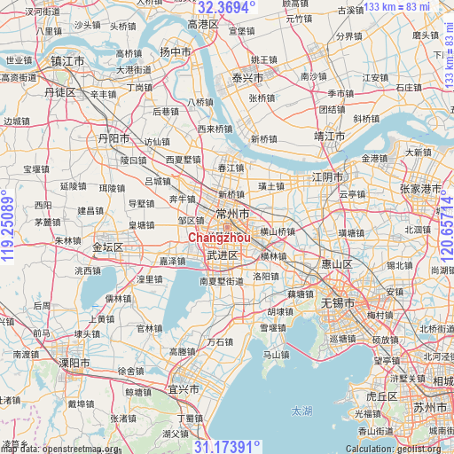
Changzhou GPS coordinates[2]
31° 46' 24.924" North, 119° 57' 14.436" East
| Map corner | latitude | longitude |
|---|---|---|
| Upper-left | 32.3694°, | 119.25089° |
| Center: | 31.77359°, | 119.95401° |
| Lower-right: | 31.17391°, | 120.65714° |
| Map W x H: | 132.9×132.9 km | = 82.6×82.6mi |
| max Lat: | 53.31946° ⇑40% North |
| Changzhou: | 31.77359° |
| min Lat: | ⇓60% South 18.22056° |
| min Long | Changzhou | max Long |
| 75.07348° | 119.95401° | 134.28917° |
| W 81.6%⇐ | ⇒18.4% E |
Elevation
Elevation of Changzhou is 9 m = 30 ft, and this is 475.8 m = 1561 ft below average elevation for this country.
| Max E: |
5622 m = 18445 ft | 91.2% |
| Avg. | 484.8 m = 1591 ft | |
| Changzhou | 9 m = 30 ft | |
Min E: |
-3 m = -10 ft | 8.8% |
See also: Changzhou elevation on elevation.city.
Geographical zone
Changzhou is located in North temperate zone (between Tropic of Cancer and the Arctic Circle). Distance of this Northern Tropic circle is 927 km =576 mi to South.| Distance of | km | miles | from Changzhou |
|---|---|---|---|
| North Pole | 6474.2 | 4022.9 | to North |
| Arctic Circle | 3868.3 | 2403.6 | to North |
| Tropic Cancer | 927 | 576 | to South |
| Equator | 3532.9 | 2195.2 | to South |


Nearby cities:
15 places around Changzhou: (largest is in red/bold)
• Beigang
7.6 km =4.7 mi,  290°
290°
• Dingyan
6.2 km =3.9 mi,  119°
119°
• Hehai
6.6 km =4.1 mi,  19°
19°
• Hutang
6.5 km =4 mi,  187°
187°
• Longhutang
9.3 km =5.8 mi, 16°
• Lucheng
8.8 km =5.5 mi,  97°
97°
• Niutang
7.1 km =4.4 mi,  232°
232°
• Qinglong
5.2 km =3.2 mi,  73°
73°
• Qishuyan
10.8 km =6.7 mi, 118°
• Xilin
6.4 km =4 mi,  265°
265°
• Xinqiao
10 km =6.2 mi,  0°
0°
• Xinzha
7.8 km =4.8 mi,  309°
309°
• Xuejia
10.4 km =6.5 mi,  338°
338°
• Yaoguan
11.1 km =6.9 mi,  138°
138°
• Zouqu
11.1 km =6.9 mi,  283°
283°
Sources, notices
• [Note1] Compared only with cities in China existing in our database
• [Src1] Map data: © OpenStreetMap contributors (CC-BY-SA)
• [Src2] Other city data from geonames.org with taken over terms of usage.
• [Src3] Geographical zone / Annual Mean Temperature by Robert A. Rohde @ Wikipedia
