Changhe geodata
Changhe (Zhejiang) is a seat of a fourth-order administrative division; located in China in Asia/Shanghai (GMT+8) time zone. In our database, there are 1268 cities with bigger population. Compared to other cities in China, 52.4% of cities are located further ↑North; 83.2% of cities are located further ←West and 88.7% of cities have higher elevation than Changhe. Note1


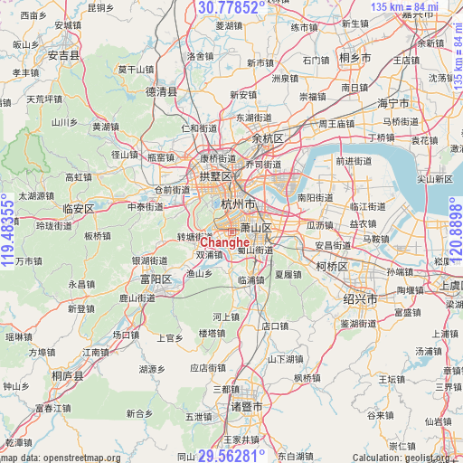
Changhe GPS coordinates[2]
30° 10' 21.144" North, 120° 11' 12.012" East
| Map corner | latitude | longitude |
|---|---|---|
| Upper-left | 30.77852°, | 119.48355° |
| Center: | 30.17254°, | 120.18667° |
| Lower-right: | 29.56281°, | 120.8898° |
| Map W x H: | 135.2×135.2 km | = 84×84mi |
| max Lat: | 53.31946° ⇑52.4% North |
| Changhe: | 30.17254° |
| min Lat: | ⇓47.6% South 18.22056° |
| min Long | Changhe | max Long |
| 75.07348° | 120.18667° | 134.28917° |
| W 83.2%⇐ | ⇒16.8% E |
Elevation
Elevation of Changhe is 11 m = 36 ft, and this is 473.8 m = 1554 ft below average elevation for this country.
| Max E: |
5622 m = 18445 ft | 88.7% |
| Avg. | 484.8 m = 1591 ft | |
| Changhe | 11 m = 36 ft | |
Min E: |
-3 m = -10 ft | 11.3% |
See also: China elevation on elevation.city.
Geographical zone
Changhe is located in North temperate zone (between Tropic of Cancer and the Arctic Circle). Distance of this Northern Tropic circle is 749 km =465.4 mi to South.| Distance of | km | miles | from Changhe |
|---|---|---|---|
| North Pole | 6652.2 | 4133.5 | to North |
| Arctic Circle | 4046.3 | 2514.3 | to North |
| Tropic Cancer | 749 | 465.4 | to South |
| Equator | 3354.9 | 2084.6 | to South |


Nearby cities:
15 places around Changhe: (largest is in red/bold)
• Gudang
13.5 km =8.4 mi,  330°
330°
• Hangzhou
13.7 km =8.5 mi,  349°
349°
• Ningwei
9.9 km =6.2 mi,  61°
61°
• Pengbu
13.6 km =8.5 mi,  13°
13°
• Puyan
4.2 km =2.6 mi,  246°
246°
• Shuangpu
9.2 km =5.7 mi,  226°
226°
• Sijiqing
8.6 km =5.3 mi,  358°
358°
• Suoqian
10.9 km =6.8 mi,  127°
127°
• Wenyan
5.3 km =3.3 mi,  197°
197°
• Xiaoshan
7 km =4.3 mi,  94°
94°
• Xihu
10.1 km =6.3 mi,  319°
319°
• Xintang
11.6 km =7.2 mi,  102°
102°
• Xixing
4.3 km =2.7 mi, 64°
• Yiqiao
11.5 km =7.1 mi,  174°
174°
• Zhuantang
10.7 km =6.6 mi,  264°
264°
Sources, notices
• [Note1] Compared only with cities in China existing in our database
• [Src1] Map data: © OpenStreetMap contributors (CC-BY-SA)
• [Src2] Other city data from geonames.org with taken over terms of usage.
• [Src3] Geographical zone / Annual Mean Temperature by Robert A. Rohde @ Wikipedia
