Qiaotou geodata
Qiaotou (Zhejiang) is a seat of a fourth-order administrative division; located in China in Asia/Shanghai (GMT+8) time zone. In our database, there are 1268 cities with bigger population. Compared to other cities in China, 52.5% of cities are located further ↑North; 89.4% of cities are located further ←West and 94.3% of cities have higher elevation than Qiaotou. Note1


Qiaotou GPS coordinates[2]
30° 9' 39.456" North, 121° 21' 24.768" East
| Map corner | latitude | longitude |
|---|---|---|
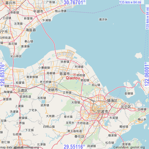
| Upper-left | 30.76701°, | 120.65376° |
| Center: | 30.16096°, | 121.35688° |
| Lower-right: | 29.55116°, | 122.06001° |
| Map W x H: | 135.2×135.2 km | = 84×84mi |
| max Lat: | 53.31946° ⇑52.5% North |
| Qiaotou: | 30.16096° |
| min Lat: | ⇓47.5% South 18.22056° |
| min Long | Qiaotou | max Long |
| 75.07348° | 121.35688° | 134.28917° |
| W 89.4%⇐ | ⇒10.6% E |
Elevation
Elevation of Qiaotou is 7 m = 23 ft, and this is 477.8 m = 1568 ft below average elevation for this country.
| Max E: |
5622 m = 18445 ft | 94.3% |
| Avg. | 484.8 m = 1591 ft | |
| Qiaotou | 7 m = 23 ft | |
Min E: |
-3 m = -10 ft | 5.7% |
See also: China elevation on elevation.city.
Geographical zone
Qiaotou is located in North temperate zone (between Tropic of Cancer and the Arctic Circle). Distance of this Northern Tropic circle is 747.7 km =464.6 mi to South.| Distance of | km | miles | from Qiaotou |
|---|---|---|---|
| North Pole | 6653.5 | 4134.3 | to North |
| Arctic Circle | 4047.6 | 2515.1 | to North |
| Tropic Cancer | 747.7 | 464.6 | to South |
| Equator | 3353.6 | 2083.8 | to South |


Nearby cities:
15 places around Qiaotou: (largest is in red/bold)
• Guanhaiwei
4.4 km =2.7 mi,  76°
76°
• Haiyanmiao
8.4 km =5.2 mi,  28°
28°
• Henghe
12 km =7.5 mi,  253°
253°
• Kandun
11.8 km =7.3 mi,  307°
307°
• Kuangyan
6 km =3.7 mi,  259°
259°
• Liutangting
15.5 km =9.6 mi,  325°
325°
• Sanbei
15.5 km =9.6 mi,  118°
118°
• Sanqishi
14.3 km =8.9 mi,  187°
187°
• Shengshan
8.7 km =5.4 mi,  337°
337°
• Xiaolin
5.1 km =3.2 mi,  284°
284°
• Xinpu
9.2 km =5.7 mi,  4°
4°
• Xushan
10.8 km =6.7 mi, 279°
• Yangjia
12.3 km =7.6 mi, 120°
• Zhangqi
10.3 km =6.4 mi, 119°
• Zonghan
13.1 km =8.1 mi,  285°
285°
Sources, notices
• [Note1] Compared only with cities in China existing in our database
• [Src1] Map data: © OpenStreetMap contributors (CC-BY-SA)
• [Src2] Other city data from geonames.org with taken over terms of usage.
• [Src3] Geographical zone / Annual Mean Temperature by Robert A. Rohde @ Wikipedia
