Hegeng geodata
Hegeng (Chongqing) is a seat of a fourth-order administrative division; located in China in Asia/Shanghai (GMT+8) time zone. In our database, there are 1268 cities with bigger population. Compared to other cities in China, 63.9% of cities are located further ↑North; 87.3% of cities are located further →East and 65.3% of cities have lower elevation than Hegeng. Note1


Hegeng GPS coordinates[2]
29° 8' 13.056" North, 105° 52' 11.568" East
| Map corner | latitude | longitude |
|---|---|---|
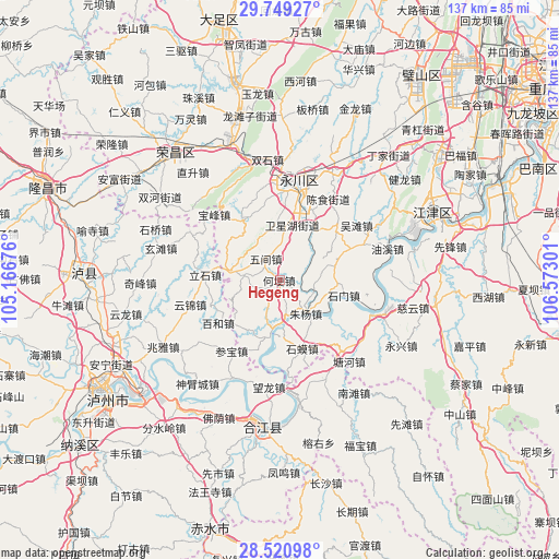
| Upper-left | 29.74927°, | 105.16676° |
| Center: | 29.13696°, | 105.86988° |
| Lower-right: | 28.52098°, | 106.57301° |
| Map W x H: | 136.6×136.6 km | = 84.9×84.9mi |
| max Lat: | 53.31946° ⇑63.9% North |
| Hegeng: | 29.13696° |
| min Lat: | ⇓36.1% South 18.22056° |
| min Long | Hegeng | max Long |
| 75.07348° | 105.86988° | 134.28917° |
| W 12.7%⇐ | ⇒87.3% E |
Elevation
Elevation of Hegeng is 332 m = 1089 ft, and this is 152.8 m = 501 ft below average elevation for this country.
| Max E: |
5622 m = 18445 ft | 34.7% |
| Avg. | 484.8 m = 1591 ft | |
| Hegeng | 332 m = 1089 ft | |
Min E: |
-3 m = -10 ft | 65.3% |
See also: China elevation on elevation.city.
Geographical zone
Hegeng is located in North temperate zone (between Tropic of Cancer and the Arctic Circle). Distance of this Northern Tropic circle is 633.8 km =393.8 mi to South.| Distance of | km | miles | from Hegeng |
|---|---|---|---|
| North Pole | 6767.3 | 4205 | to North |
| Arctic Circle | 4161.4 | 2585.8 | to North |
| Tropic Cancer | 633.8 | 393.8 | to South |
| Equator | 3239.7 | 2013.1 | to South |


Nearby cities:
15 places around Hegeng: (largest is in red/bold)
• Baofeng
22.6 km =14 mi,  315°
315°
• Ji’an
12.2 km =7.6 mi,  281°
281°
• Laisu
16.9 km =10.5 mi,  328°
328°
• Linjiang
14.7 km =9.1 mi,  34°
34°
• Nandajie
22.4 km =13.9 mi,  5°
5°
• Qingfeng
22.9 km =14.2 mi,  349°
349°
• Shima
17.4 km =10.8 mi,  162°
162°
• Shimen
16.4 km =10.2 mi,  104°
104°
• Shuangzhu
13.8 km =8.6 mi, 13°
• Songgai
9.1 km =5.7 mi,  166°
166°
• Wujian
6.1 km =3.8 mi, 325°
• Wutan
23 km =14.3 mi,  54°
54°
• Xianlong
8.5 km =5.3 mi, 280°
• Zhutuo
13.3 km =8.3 mi,  188°
188°
• Zhuyang
10.9 km =6.8 mi,  137°
137°
Sources, notices
• [Note1] Compared only with cities in China existing in our database
• [Src1] Map data: © OpenStreetMap contributors (CC-BY-SA)
• [Src2] Other city data from geonames.org with taken over terms of usage.
• [Src3] Geographical zone / Annual Mean Temperature by Robert A. Rohde @ Wikipedia
