Jinshi geodata
Jinshi (Guangdong) is a seat of a fourth-order administrative division; located in China in Asia/Shanghai (GMT+8) time zone. In our database, there are 1268 cities with bigger population. Compared to other cities in China, 92% of cities are located further ↑North; 63.8% of cities are located further ←West and 91.2% of cities have higher elevation than Jinshi. Note1


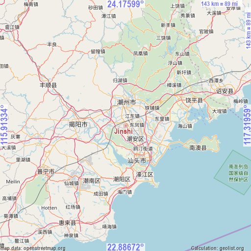
Jinshi GPS coordinates[2]
23° 31' 58.548" North, 116° 36' 59.256" East
| Map corner | latitude | longitude |
|---|---|---|
| Upper-left | 24.17599°, | 115.91334° |
| Center: | 23.53293°, | 116.61646° |
| Lower-right: | 22.88672°, | 117.31959° |
| Map W x H: | 143.4×143.4 km | = 89.1×89.1mi |
| max Lat: | 53.31946° ⇑92% North |
| Jinshi: | 23.53293° |
| min Lat: | ⇓8% South 18.22056° |
| min Long | Jinshi | max Long |
| 75.07348° | 116.61646° | 134.28917° |
| W 63.8%⇐ | ⇒36.2% E |
Elevation
Elevation of Jinshi is 9 m = 30 ft, and this is 475.8 m = 1561 ft below average elevation for this country.
| Max E: |
5622 m = 18445 ft | 91.2% |
| Avg. | 484.8 m = 1591 ft | |
| Jinshi | 9 m = 30 ft | |
Min E: |
-3 m = -10 ft | 8.8% |
See also: China elevation on elevation.city.
Geographical zone
Jinshi is located in North temperate zone (between Tropic of Cancer and the Arctic Circle). Distance of this Northern Tropic circle is 10.7 km =6.6 mi to South.| Distance of | km | miles | from Jinshi |
|---|---|---|---|
| North Pole | 7390.4 | 4592.2 | to North |
| Arctic Circle | 4784.6 | 2973 | to North |
| Tropic Cancer | 10.7 | 6.6 | to South |
| Equator | 2616.6 | 1625.9 | to South |


Nearby cities:
15 places around Jinshi: (largest is in red/bold)
• Anbu
11.4 km =7.1 mi,  144°
144°
• Caitang
7 km =4.3 mi, 135°
• Chaozhou
13.5 km =8.4 mi,  2°
2°
• Denggang
10.3 km =6.4 mi,  277°
277°
• Didou
9.5 km =5.9 mi,  212°
212°
• Dongfeng
6.7 km =4.2 mi,  81°
81°
• Fengtang
11.5 km =7.1 mi,  336°
336°
• Fuyang
5.7 km =3.5 mi,  325°
325°
• Jiangdong
7.8 km =4.8 mi,  36°
36°
• Longdu
11.8 km =7.3 mi,  68°
68°
• Longhu
4.1 km =2.5 mi,  48°
48°
• Paotai
12.4 km =7.7 mi,  264°
264°
• Shanghua
9.5 km =5.9 mi,  96°
96°
• Shaxi
3.1 km =1.9 mi, 255°
• Tuotang
13 km =8.1 mi,  193°
193°
Sources, notices
• [Note1] Compared only with cities in China existing in our database
• [Src1] Map data: © OpenStreetMap contributors (CC-BY-SA)
• [Src2] Other city data from geonames.org with taken over terms of usage.
• [Src3] Geographical zone / Annual Mean Temperature by Robert A. Rohde @ Wikipedia
