Mao’er geodata
Mao’er (Hunan) is a seat of a fourth-order administrative division; located in China in Asia/Shanghai (GMT+8) time zone. In our database, there are 1268 cities with bigger population. Compared to other cities in China, 70.4% of cities are located further ↑North; 74.7% of cities are located further →East and 75% of cities have lower elevation than Mao’er. Note1


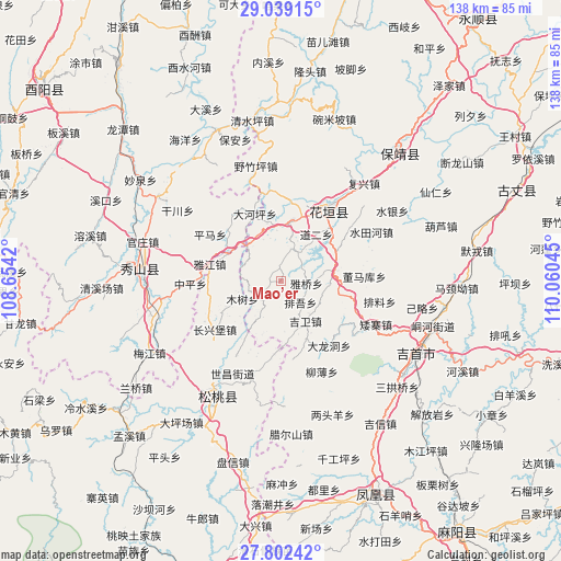
Mao’er GPS coordinates[2]
28° 25' 21.324" North, 109° 21' 26.352" East
| Map corner | latitude | longitude |
|---|---|---|
| Upper-left | 29.03915°, | 108.6542° |
| Center: | 28.42259°, | 109.35732° |
| Lower-right: | 27.80242°, | 110.06045° |
| Map W x H: | 137.5×137.5 km | = 85.4×85.4mi |
| max Lat: | 53.31946° ⇑70.4% North |
| Mao’er: | 28.42259° |
| min Lat: | ⇓29.6% South 18.22056° |
| min Long | Mao’er | max Long |
| 75.07348° | 109.35732° | 134.28917° |
| W 25.3%⇐ | ⇒74.7% E |
Elevation
Elevation of Mao’er is 521 m = 1709 ft, and this is 36.2 m = 119 ft above average elevation for this country.
| Max E: |
5622 m = 18445 ft | 25% |
| Mao’er | 521 m 1709 ft | |
| Avg. | 484.8 m = 1591 ft | |
Min E: |
-3 m = -10 ft | 75% |
See also: China elevation on elevation.city.
Geographical zone
Mao’er is located in North temperate zone (between Tropic of Cancer and the Arctic Circle). Distance of this Northern Tropic circle is 554.4 km =344.5 mi to South.| Distance of | km | miles | from Mao’er |
|---|---|---|---|
| North Pole | 6846.8 | 4254.4 | to North |
| Arctic Circle | 4240.9 | 2635.2 | to North |
| Tropic Cancer | 554.4 | 344.5 | to South |
| Equator | 3160.3 | 1963.7 | to South |


Nearby cities:
15 places around Mao’er: (largest is in red/bold)
• Buchou
15.7 km =9.8 mi,  156°
156°
• Chadong
12.2 km =7.6 mi,  329°
329°
• Dao’er
13.1 km =8.1 mi,  38°
38°
• Hong’an
12.5 km =7.8 mi,  314°
314°
• Jiwei
11.5 km =7.1 mi,  149°
149°
• Longtan
8.1 km =5 mi,  24°
24°
• Malichang
13.2 km =8.2 mi,  83°
83°
• Minle
7.1 km =4.4 mi,  234°
234°
• Mushu
10.5 km =6.5 mi,  245°
245°
• Paibi
17.8 km =11.1 mi,  104°
104°
• Paiwu
8.1 km =5 mi,  141°
141°
• Tuanjie
14.2 km =8.8 mi,  7°
7°
• Woshao
15.1 km =9.4 mi,  53°
53°
• Yajia
17.3 km =10.7 mi,  281°
281°
• Yaqiao
6.1 km =3.8 mi, 95°
Sources, notices
• [Note1] Compared only with cities in China existing in our database
• [Src1] Map data: © OpenStreetMap contributors (CC-BY-SA)
• [Src2] Other city data from geonames.org with taken over terms of usage.
• [Src3] Geographical zone / Annual Mean Temperature by Robert A. Rohde @ Wikipedia
