Jiufeng geodata
Jiufeng (Shaanxi) is a seat of a fourth-order administrative division; located in China in Asia/Shanghai (GMT+8) time zone. In our database, there are 1268 cities with bigger population. Compared to other cities in China, 70.6% of cities are located further ↓South; 78.9% of cities are located further →East and 71.4% of cities have lower elevation than Jiufeng. Note1


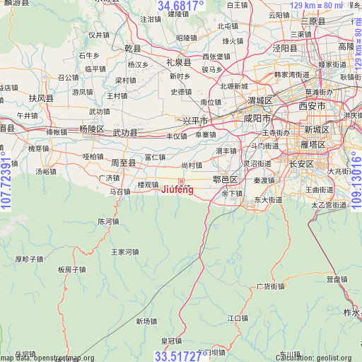
Jiufeng GPS coordinates[2]
34° 6' 5.364" North, 108° 25' 37.308" East
| Map corner | latitude | longitude |
|---|---|---|
| Upper-left | 34.6817°, | 107.72391° |
| Center: | 34.10149°, | 108.42703° |
| Lower-right: | 33.51727°, | 109.13016° |
| Map W x H: | 129.5×129.5 km | = 80.5×80.5mi |
| max Lat: | 53.31946° ⇑29.4% North |
| Jiufeng: | 34.10149° |
| min Lat: | ⇓70.6% South 18.22056° |
| min Long | Jiufeng | max Long |
| 75.07348° | 108.42703° | 134.28917° |
| W 21.1%⇐ | ⇒78.9% E |
Elevation
Elevation of Jiufeng is 438 m = 1437 ft, and this is 46.8 m = 154 ft below average elevation for this country.
| Max E: |
5622 m = 18445 ft | 28.6% |
| Avg. | 484.8 m = 1591 ft | |
| Jiufeng | 438 m = 1437 ft | |
Min E: |
-3 m = -10 ft | 71.4% |
See also: China elevation on elevation.city.
Geographical zone
Jiufeng is located in North temperate zone (between Tropic of Cancer and the Arctic Circle). Distance of this Northern Tropic circle is 1185.8 km =736.8 mi to South.| Distance of | km | miles | from Jiufeng |
|---|---|---|---|
| North Pole | 6215.3 | 3862 | to North |
| Arctic Circle | 3609.4 | 2242.8 | to North |
| Tropic Cancer | 1185.8 | 736.8 | to South |
| Equator | 3791.7 | 2356.1 | to South |


Nearby cities:
15 places around Jiufeng: (largest is in red/bold)
• Fengyi
16.5 km =10.3 mi,  354°
354°
• Ganhe
10.2 km =6.3 mi,  52°
52°
• Ganting
17.2 km =10.7 mi,  89°
89°
• Jiangcun
4.8 km =3 mi,  115°
115°
• Jixian
3 km =1.9 mi,  241°
241°
• Laodian
14.8 km =9.2 mi,  58°
58°
• Louguan
11.8 km =7.3 mi,  265°
265°
• Sangzhen
18.7 km =11.6 mi,  336°
336°
• Shangcun
7.1 km =4.4 mi,  32°
32°
• Shijing
17 km =10.6 mi, 118°
• Tangfang
16.2 km =10.1 mi, 338°
• Tianqiao
13.6 km =8.5 mi,  113°
113°
• Zhongnan
8 km =5 mi,  309°
309°
• Zhuangtou
17.5 km =10.9 mi,  7°
7°
• Zu’an
5.3 km =3.3 mi,  97°
97°
Sources, notices
• [Note1] Compared only with cities in China existing in our database
• [Src1] Map data: © OpenStreetMap contributors (CC-BY-SA)
• [Src2] Other city data from geonames.org with taken over terms of usage.
• [Src3] Geographical zone / Annual Mean Temperature by Robert A. Rohde @ Wikipedia
