Chongwen geodata
Chongwen (Shaanxi) is a seat of a fourth-order administrative division; located in China in Asia/Shanghai (GMT+8) time zone. In our database, there are 1268 cities with bigger population. Compared to other cities in China, 72.7% of cities are located further ↓South; 76.6% of cities are located further →East and 68.3% of cities have lower elevation than Chongwen. Note1


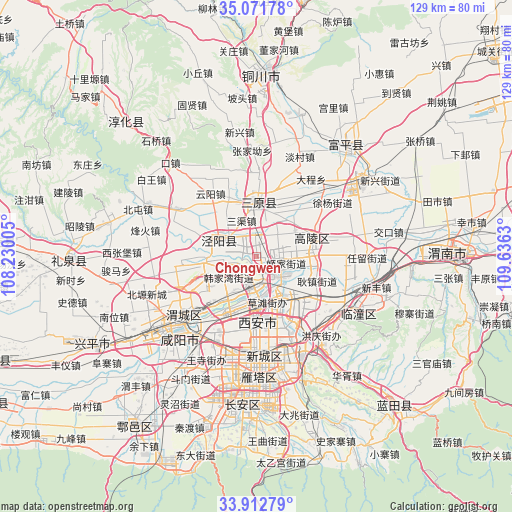
Chongwen GPS coordinates[2]
34° 29' 39.48" North, 108° 55' 59.412" East
| Map corner | latitude | longitude |
|---|---|---|
| Upper-left | 35.07178°, | 108.23005° |
| Center: | 34.4943°, | 108.93317° |
| Lower-right: | 33.91279°, | 109.6363° |
| Map W x H: | 128.9×128.9 km | = 80.1×80.1mi |
| max Lat: | 53.31946° ⇑27.3% North |
| Chongwen: | 34.4943° |
| min Lat: | ⇓72.7% South 18.22056° |
| min Long | Chongwen | max Long |
| 75.07348° | 108.93317° | 134.28917° |
| W 23.4%⇐ | ⇒76.6% E |
Elevation
Elevation of Chongwen is 382 m = 1253 ft, and this is 102.8 m = 337 ft below average elevation for this country.
| Max E: |
5622 m = 18445 ft | 31.7% |
| Avg. | 484.8 m = 1591 ft | |
| Chongwen | 382 m = 1253 ft | |
Min E: |
-3 m = -10 ft | 68.3% |
See also: China elevation on elevation.city.
Geographical zone
Chongwen is located in North temperate zone (between Tropic of Cancer and the Arctic Circle). Distance of this Northern Tropic circle is 1229.5 km =764 mi to South.| Distance of | km | miles | from Chongwen |
|---|---|---|---|
| North Pole | 6171.7 | 3834.9 | to North |
| Arctic Circle | 3565.8 | 2215.7 | to North |
| Tropic Cancer | 1229.5 | 764 | to South |
| Equator | 3835.4 | 2383.2 | to South |


Nearby cities:
15 places around Chongwen: (largest is in red/bold)
• Anle
13.8 km =8.6 mi,  34°
34°
• Caotan
11.5 km =7.1 mi,  162°
162°
• Gaozhuang
3.4 km =2.1 mi,  189°
189°
• Gengzhen
16.5 km =10.3 mi,  112°
112°
• Jinggan
9.9 km =6.2 mi,  293°
293°
• Luyuan
14.7 km =9.1 mi,  71°
71°
• Sanqu
9.7 km =6 mi,  337°
337°
• Sanyuan Chengguanzhen
13.4 km =8.3 mi,  358°
358°
• Tongyuan
11.8 km =7.3 mi,  56°
56°
• Xinzhu
16.5 km =10.3 mi,  137°
137°
• Yanwang
14.8 km =9.2 mi,  305°
305°
• Yaodian
12.2 km =7.6 mi,  217°
217°
• Yongle
4.3 km =2.7 mi,  5°
5°
• Yuchu
11.5 km =7.1 mi,  85°
85°
• Zhengyang
7.9 km =4.9 mi, 187°
Sources, notices
• [Note1] Compared only with cities in China existing in our database
• [Src1] Map data: © OpenStreetMap contributors (CC-BY-SA)
• [Src2] Other city data from geonames.org with taken over terms of usage.
• [Src3] Geographical zone / Annual Mean Temperature by Robert A. Rohde @ Wikipedia
