Gaopi geodata
Gaopi (Guangdong) is a seat of a fourth-order administrative division; located in China in Asia/Shanghai (GMT+8) time zone. In our database, there are 1268 cities with bigger population. Compared to other cities in China, 89.7% of cities are located further ↑North; 63.9% of cities are located further ←West and 67.2% of cities have higher elevation than Gaopi. Note1


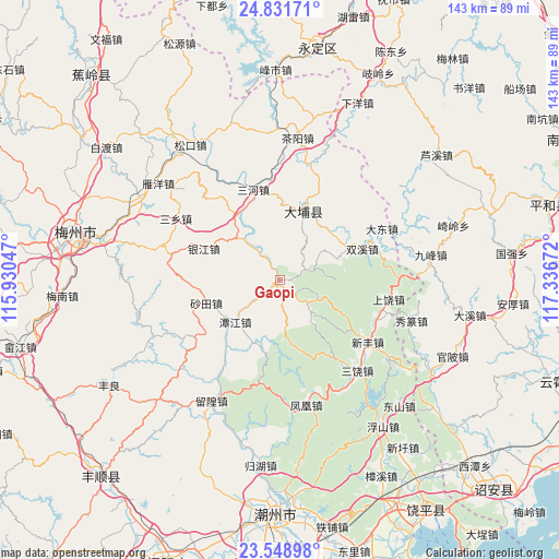
Gaopi GPS coordinates[2]
24° 11' 31.056" North, 116° 38' 0.924" East
| Map corner | latitude | longitude |
|---|---|---|
| Upper-left | 24.83171°, | 115.93047° |
| Center: | 24.19196°, | 116.63359° |
| Lower-right: | 23.54898°, | 117.33672° |
| Map W x H: | 142.6×142.6 km | = 88.6×88.6mi |
| max Lat: | 53.31946° ⇑89.7% North |
| Gaopi: | 24.19196° |
| min Lat: | ⇓10.3% South 18.22056° |
| min Long | Gaopi | max Long |
| 75.07348° | 116.63359° | 134.28917° |
| W 63.9%⇐ | ⇒36.1% E |
Elevation
Elevation of Gaopi is 64 m = 210 ft, and this is 420.8 m = 1381 ft below average elevation for this country.
| Max E: |
5622 m = 18445 ft | 67.2% |
| Avg. | 484.8 m = 1591 ft | |
| Gaopi | 64 m = 210 ft | |
Min E: |
-3 m = -10 ft | 32.8% |
See also: China elevation on elevation.city.
Geographical zone
Gaopi is located in North temperate zone (between Tropic of Cancer and the Arctic Circle). Distance of this Northern Tropic circle is 84 km =52.2 mi to South.| Distance of | km | miles | from Gaopi |
|---|---|---|---|
| North Pole | 7317.2 | 4546.7 | to North |
| Arctic Circle | 4711.3 | 2927.5 | to North |
| Tropic Cancer | 84 | 52.2 | to South |
| Equator | 2689.9 | 1671.4 | to South |


Nearby cities:
15 places around Gaopi: (largest is in red/bold)
• Baihou
18.2 km =11.3 mi,  47°
47°
• Dama
19.9 km =12.4 mi,  327°
327°
• Fenglang
18.7 km =11.6 mi,  65°
65°
• Guangde
11.4 km =7.1 mi,  118°
118°
• Guye
1.1 km =0.7 mi,  280°
280°
• Huliao
19.2 km =11.9 mi,  16°
16°
• Pingyuan
8.3 km =5.2 mi, 74°
• Shatian
19.7 km =12.2 mi,  253°
253°
• Shuangxi
22.4 km =13.9 mi, 68°
• Tanjiang
15.4 km =9.6 mi,  227°
227°
• Tanshan
18.5 km =11.5 mi,  194°
194°
• Taoyuan
11.8 km =7.3 mi,  175°
175°
• Xiaosheng
22.9 km =14.2 mi, 232°
• Yinjiang
21.1 km =13.1 mi,  292°
292°
• Zhourui
8.3 km =5.2 mi, 279°
Sources, notices
• [Note1] Compared only with cities in China existing in our database
• [Src1] Map data: © OpenStreetMap contributors (CC-BY-SA)
• [Src2] Other city data from geonames.org with taken over terms of usage.
• [Src3] Geographical zone / Annual Mean Temperature by Robert A. Rohde @ Wikipedia
