Baigecun geodata
Baigecun (Yunnan) is a seat of a fourth-order administrative division; located in China in Asia/Shanghai (GMT+8) time zone. In our database, there are 1268 cities with bigger population. Compared to other cities in China, 89.8% of cities are located further ↑North; 92.1% of cities are located further →East and 94.2% of cities have lower elevation than Baigecun. Note1


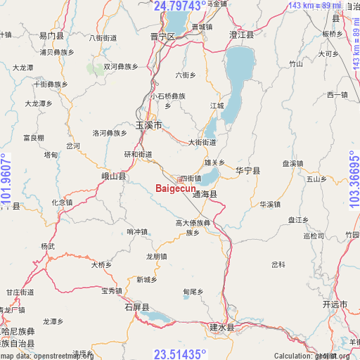
Baigecun GPS coordinates[2]
24° 9' 27" North, 102° 39' 49.752" East
| Map corner | latitude | longitude |
|---|---|---|
| Upper-left | 24.79743°, | 101.9607° |
| Center: | 24.1575°, | 102.66382° |
| Lower-right: | 23.51435°, | 103.36695° |
| Map W x H: | 142.7×142.7 km | = 88.7×88.7mi |
| max Lat: | 53.31946° ⇑89.8% North |
| Baigecun: | 24.1575° |
| min Lat: | ⇓10.2% South 18.22056° |
| min Long | Baigecun | max Long |
| 75.07348° | 102.66382° | 134.28917° |
| W 7.9%⇐ | ⇒92.1% E |
Elevation
Elevation of Baigecun is 1896 m = 6220 ft, and this is 1411.2 m = 4630 ft above average elevation for this country.
| Max E: |
5622 m = 18445 ft | 5.8% |
| Baigecun | 1896 m 6220 ft | |
| Avg. | 484.8 m = 1591 ft | |
Min E: |
-3 m = -10 ft | 94.2% |
See also: China elevation on elevation.city.
Geographical zone
Baigecun is located in North temperate zone (between Tropic of Cancer and the Arctic Circle). Distance of this Northern Tropic circle is 80.1 km =49.8 mi to South.| Distance of | km | miles | from Baigecun |
|---|---|---|---|
| North Pole | 7321 | 4549.1 | to North |
| Arctic Circle | 4715.1 | 2929.8 | to North |
| Tropic Cancer | 80.1 | 49.8 | to South |
| Equator | 2686.1 | 1669.1 | to South |


Nearby cities:
15 places around Baigecun: (largest is in red/bold)
• Dajie
17.8 km =11.1 mi,  29°
29°
• Dayingjie
16.8 km =10.4 mi,  351°
351°
• Gaocang
23.3 km =14.5 mi,  321°
321°
• Hexi
2.2 km =1.4 mi,  224°
224°
• Jiujie
5.4 km =3.4 mi,  154°
154°
• Lishan
12.9 km =8 mi,  137°
137°
• Najiaying
8.1 km =5 mi,  69°
69°
• Qianwei
21.5 km =13.4 mi,  17°
17°
• Sijie
4.3 km =2.7 mi,  76°
76°
• Xiaojie
20.6 km =12.8 mi,  270°
270°
• Xiongguan
15.8 km =9.8 mi,  61°
61°
• Xiushan
11.2 km =7 mi,  118°
118°
• Yangguang
13.4 km =8.3 mi,  99°
99°
• Yanhe
20.4 km =12.7 mi,  303°
303°
• Yuxi
25.2 km =15.7 mi,  330°
330°
Sources, notices
• [Note1] Compared only with cities in China existing in our database
• [Src1] Map data: © OpenStreetMap contributors (CC-BY-SA)
• [Src2] Other city data from geonames.org with taken over terms of usage.
• [Src3] Geographical zone / Annual Mean Temperature by Robert A. Rohde @ Wikipedia
