Menlou’ao geodata
Menlou’ao (Zhejiang) is a seat of a fourth-order administrative division; located in China in Asia/Shanghai (GMT+8) time zone. In our database, there are 1268 cities with bigger population. Compared to other cities in China, 76.8% of cities are located further ↑North; 81% of cities are located further ←West and 77% of cities have lower elevation than Menlou’ao. Note1


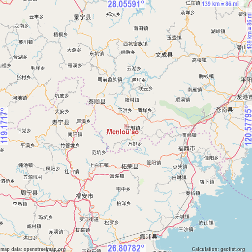
Menlou’ao GPS coordinates[2]
27° 26' 1.068" North, 119° 52' 29.352" East
| Map corner | latitude | longitude |
|---|---|---|
| Upper-left | 28.05591°, | 119.1717° |
| Center: | 27.43363°, | 119.87482° |
| Lower-right: | 26.80782°, | 120.57795° |
| Map W x H: | 138.8×138.8 km | = 86.2×86.2mi |
| max Lat: | 53.31946° ⇑76.8% North |
| Menlou’ao: | 27.43363° |
| min Lat: | ⇓23.2% South 18.22056° |
| min Long | Menlou’ao | max Long |
| 75.07348° | 119.87482° | 134.28917° |
| W 81%⇐ | ⇒19% E |
Elevation
Elevation of Menlou’ao is 576 m = 1890 ft, and this is 91.2 m = 299 ft above average elevation for this country.
| Max E: |
5622 m = 18445 ft | 23% |
| Menlou’ao | 576 m 1890 ft | |
| Avg. | 484.8 m = 1591 ft | |
Min E: |
-3 m = -10 ft | 77% |
See also: China elevation on elevation.city.
Geographical zone
Menlou’ao is located in North temperate zone (between Tropic of Cancer and the Arctic Circle). Distance of this Northern Tropic circle is 444.4 km =276.1 mi to South.| Distance of | km | miles | from Menlou’ao |
|---|---|---|---|
| North Pole | 6956.7 | 4322.7 | to North |
| Arctic Circle | 4350.8 | 2703.5 | to North |
| Tropic Cancer | 444.4 | 276.1 | to South |
| Equator | 3050.3 | 1895.4 | to South |


Nearby cities:
15 places around Menlou’ao: (largest is in red/bold)
• Da’an
2.4 km =1.5 mi,  16°
16°
• Dongxi
8.5 km =5.3 mi,  97°
97°
• Fengyang
13.7 km =8.5 mi,  48°
48°
• Guihu
14.1 km =8.8 mi,  209°
209°
• Liufeng
12.7 km =7.9 mi,  111°
111°
• Nanyuan
10.7 km =6.6 mi,  296°
296°
• Sankui
3.8 km =2.4 mi, 98°
• Shiyang
7.6 km =4.7 mi,  163°
163°
• Wanpai
10.6 km =6.6 mi,  152°
152°
• Xiahong
9.1 km =5.7 mi,  356°
356°
• Xiaocun
15.2 km =9.4 mi,  12°
12°
• Xiyang
0.3 km =0.2 mi,  333°
333°
• Xuexi
5.8 km =3.6 mi,  135°
135°
• Yangxi
7.7 km =4.8 mi,  243°
243°
• Zhouling
13.6 km =8.5 mi,  268°
268°
Sources, notices
• [Note1] Compared only with cities in China existing in our database
• [Src1] Map data: © OpenStreetMap contributors (CC-BY-SA)
• [Src2] Other city data from geonames.org with taken over terms of usage.
• [Src3] Geographical zone / Annual Mean Temperature by Robert A. Rohde @ Wikipedia
