Longtoushan geodata
Longtoushan (Jiangxi) is a seat of a fourth-order administrative division; located in China in Asia/Shanghai (GMT+8) time zone. In our database, there are 1268 cities with bigger population. Compared to other cities in China, 65.9% of cities are located further ↑North; 70% of cities are located further ←West and 57.5% of cities have higher elevation than Longtoushan. Note1


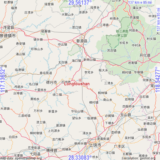
Longtoushan GPS coordinates[2]
28° 56' 52.548" North, 117° 50' 22.704" East
| Map corner | latitude | longitude |
|---|---|---|
| Upper-left | 29.56137°, | 117.13652° |
| Center: | 28.94793°, | 117.83964° |
| Lower-right: | 28.33083°, | 118.54277° |
| Map W x H: | 136.8×136.8 km | = 85×85mi |
| max Lat: | 53.31946° ⇑65.9% North |
| Longtoushan: | 28.94793° |
| min Lat: | ⇓34.1% South 18.22056° |
| min Long | Longtoushan | max Long |
| 75.07348° | 117.83964° | 134.28917° |
| W 70%⇐ | ⇒30% E |
Elevation
Elevation of Longtoushan is 114 m = 374 ft, and this is 370.8 m = 1217 ft below average elevation for this country.
| Max E: |
5622 m = 18445 ft | 57.5% |
| Avg. | 484.8 m = 1591 ft | |
| Longtoushan | 114 m = 374 ft | |
Min E: |
-3 m = -10 ft | 42.5% |
See also: China elevation on elevation.city.
Geographical zone
Longtoushan is located in North temperate zone (between Tropic of Cancer and the Arctic Circle). Distance of this Northern Tropic circle is 612.8 km =380.8 mi to South.| Distance of | km | miles | from Longtoushan |
|---|---|---|---|
| North Pole | 6788.4 | 4218.1 | to North |
| Arctic Circle | 4182.5 | 2598.9 | to North |
| Tropic Cancer | 612.8 | 380.8 | to South |
| Equator | 3218.7 | 2000 | to South |


Nearby cities:
15 places around Longtoushan: (largest is in red/bold)
• Fengzhou
31.2 km =19.4 mi,  297°
297°
• Haikou
17.9 km =11.1 mi,  349°
349°
• Huatanshan
26.5 km =16.5 mi,  185°
185°
• Lizhai
10.2 km =6.3 mi,  48°
48°
• Meilin
26.9 km =16.7 mi,  7°
7°
• Nanshan
28.8 km =17.9 mi,  123°
123°
• Sanqing
24.8 km =15.4 mi,  95°
95°
• Sizhou
16.7 km =10.4 mi,  310°
310°
• Taibai
21.3 km =13.2 mi,  316°
316°
• Tanbuqiao
21.5 km =13.4 mi,  287°
287°
• Xiangtun
29.9 km =18.6 mi,  282°
282°
• Xingangshan
20.1 km =12.5 mi,  29°
29°
• Xinjian
21.8 km =13.5 mi, 25°
• Zhengfang
27.9 km =17.3 mi,  170°
170°
• Zihu
31 km =19.3 mi, 98°
Sources, notices
• [Note1] Compared only with cities in China existing in our database
• [Src1] Map data: © OpenStreetMap contributors (CC-BY-SA)
• [Src2] Other city data from geonames.org with taken over terms of usage.
• [Src3] Geographical zone / Annual Mean Temperature by Robert A. Rohde @ Wikipedia
