Xinghua geodata
Xinghua (Gansu) is a seat of a fourth-order administrative division; located in China in Asia/Shanghai (GMT+8) time zone. In our database, there are 1268 cities with bigger population. Compared to other cities in China, 70.5% of cities are located further ↓South; 89.6% of cities are located further →East and 95% of cities have lower elevation than Xinghua. Note1


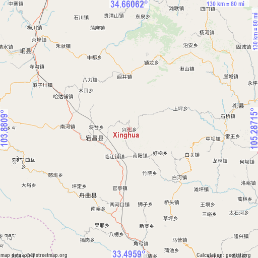
Xinghua GPS coordinates[2]
34° 4' 48.936" North, 104° 35' 2.472" East
| Map corner | latitude | longitude |
|---|---|---|
| Upper-left | 34.66062°, | 103.8809° |
| Center: | 34.08026°, | 104.58402° |
| Lower-right: | 33.4959°, | 105.28715° |
| Map W x H: | 129.5×129.5 km | = 80.5×80.5mi |
| max Lat: | 53.31946° ⇑29.5% North |
| Xinghua: | 34.08026° |
| min Lat: | ⇓70.5% South 18.22056° |
| min Long | Xinghua | max Long |
| 75.07348° | 104.58402° | 134.28917° |
| W 10.4%⇐ | ⇒89.6% E |
Elevation
Elevation of Xinghua is 2138 m = 7014 ft, and this is 1653.2 m = 5424 ft above average elevation for this country.
| Max E: |
5622 m = 18445 ft | 5% |
| Xinghua | 2138 m 7014 ft | |
| Avg. | 484.8 m = 1591 ft | |
Min E: |
-3 m = -10 ft | 95% |
See also: China elevation on elevation.city.
Geographical zone
Xinghua is located in North temperate zone (between Tropic of Cancer and the Arctic Circle). Distance of this Northern Tropic circle is 1183.5 km =735.4 mi to South.| Distance of | km | miles | from Xinghua |
|---|---|---|---|
| North Pole | 6217.7 | 3863.5 | to North |
| Arctic Circle | 3611.8 | 2244.3 | to North |
| Tropic Cancer | 1183.5 | 735.4 | to South |
| Equator | 3789.4 | 2354.6 | to South |


Nearby cities:
15 places around Xinghua: (largest is in red/bold)
• Chela
11.3 km =7 mi,  263°
263°
• Dangchang Chengguanzhen
17.9 km =11.1 mi, 257°
• Ganjiangtou
17.9 km =11.1 mi,  198°
198°
• Guanting
29.7 km =18.5 mi,  189°
189°
• Guan’e
19.1 km =11.9 mi,  246°
246°
• Hanyuan
17 km =10.6 mi,  145°
145°
• Haoli
23.4 km =14.5 mi,  117°
117°
• Hejiabao
25.2 km =15.7 mi, 258°
• Jiahe
18.9 km =11.7 mi,  273°
273°
• Jiangtai
16.3 km =10.1 mi, 273°
• Linjiang
14.9 km =9.3 mi,  207°
207°
• Lujing Zhen
26.7 km =16.6 mi,  354°
354°
• Nanyang
14.7 km =9.1 mi,  158°
158°
• Xinchengzi
14.9 km =9.3 mi,  241°
241°
• Zhuyuan
24.3 km =15.1 mi, 153°
Sources, notices
• [Note1] Compared only with cities in China existing in our database
• [Src1] Map data: © OpenStreetMap contributors (CC-BY-SA)
• [Src2] Other city data from geonames.org with taken over terms of usage.
• [Src3] Geographical zone / Annual Mean Temperature by Robert A. Rohde @ Wikipedia
