Zongzhai geodata
Zongzhai (Gansu) is a seat of a fourth-order administrative division; located in China in Asia/Shanghai (GMT+8) time zone. In our database, there are 1268 cities with bigger population. Compared to other cities in China, 73% of cities are located further ↓South; 90.7% of cities are located further →East and 95.8% of cities have lower elevation than Zongzhai. Note1


Zongzhai GPS coordinates[2]
34° 33' 9.756" North, 103° 41' 19.428" East
| Map corner | latitude | longitude |
|---|---|---|
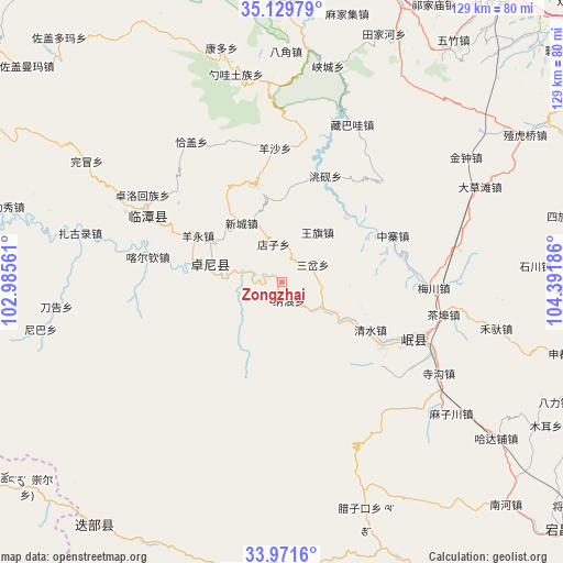
| Upper-left | 35.12979°, | 102.98561° |
| Center: | 34.55271°, | 103.68873° |
| Lower-right: | 33.9716°, | 104.39186° |
| Map W x H: | 128.8×128.8 km | = 80×80mi |
| max Lat: | 53.31946° ⇑27% North |
| Zongzhai: | 34.55271° |
| min Lat: | ⇓73% South 18.22056° |
| min Long | Zongzhai | max Long |
| 75.07348° | 103.68873° | 134.28917° |
| W 9.3%⇐ | ⇒90.7% E |
Elevation
Elevation of Zongzhai is 2465 m = 8087 ft, and this is 1980.2 m = 6497 ft above average elevation for this country.
| Max E: |
5622 m = 18445 ft | 4.2% |
| Zongzhai | 2465 m 8087 ft | |
| Avg. | 484.8 m = 1591 ft | |
Min E: |
-3 m = -10 ft | 95.8% |
See also: China elevation on elevation.city.
Geographical zone
Zongzhai is located in North temperate zone (between Tropic of Cancer and the Arctic Circle). Distance of this Northern Tropic circle is 1236 km =768 mi to South.| Distance of | km | miles | from Zongzhai |
|---|---|---|---|
| North Pole | 6165.2 | 3830.9 | to North |
| Arctic Circle | 3559.3 | 2211.6 | to North |
| Tropic Cancer | 1236 | 768 | to South |
| Equator | 3841.9 | 2387.2 | to South |


Nearby cities:
15 places around Zongzhai: (largest is in red/bold)
• Baozi
21.9 km =13.6 mi,  53°
53°
• Biandu
12.5 km =7.8 mi,  339°
339°
• Chenqi
20.5 km =12.7 mi,  43°
43°
• Dianzi
9 km =5.6 mi,  345°
345°
• Liulin
17.4 km =10.8 mi,  283°
283°
• Liushun
17.2 km =10.7 mi,  308°
308°
• Longyuan
13.9 km =8.6 mi, 35°
• Mu’er
9.6 km =6 mi, 278°
• Nalang
4.3 km =2.7 mi,  165°
165°
• Sancha
7.7 km =4.8 mi,  59°
59°
• Shimen
20.4 km =12.7 mi,  3°
3°
• Weixin
20.8 km =12.9 mi, 52°
• Xinbao
7.1 km =4.4 mi,  289°
289°
• Xincheng
16.4 km =10.2 mi,  325°
325°
• Xizhai
12.3 km =7.6 mi,  122°
122°
Sources, notices
• [Note1] Compared only with cities in China existing in our database
• [Src1] Map data: © OpenStreetMap contributors (CC-BY-SA)
• [Src2] Other city data from geonames.org with taken over terms of usage.
• [Src3] Geographical zone / Annual Mean Temperature by Robert A. Rohde @ Wikipedia
