Duobao geodata
Duobao (Jiangxi) is a seat of a fourth-order administrative division; located in China in Asia/Shanghai (GMT+8) time zone. In our database, there are 1268 cities with bigger population. Compared to other cities in China, 60.8% of cities are located further ↑North; 60.7% of cities are located further ←West and 76.2% of cities have higher elevation than Duobao. Note1


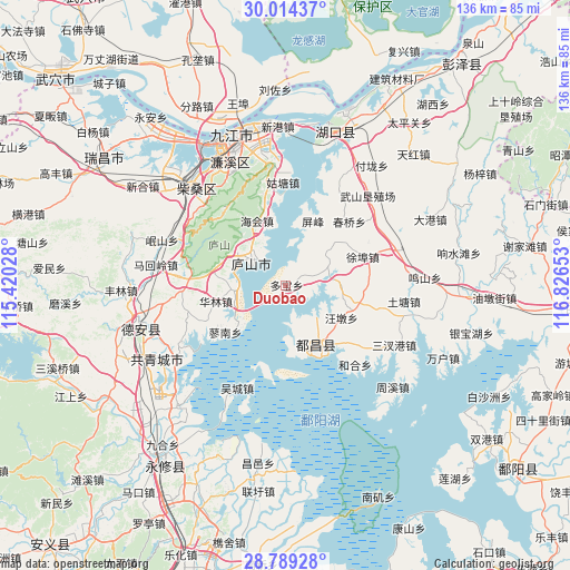
Duobao GPS coordinates[2]
29° 24' 13.212" North, 116° 7' 24.24" East
| Map corner | latitude | longitude |
|---|---|---|
| Upper-left | 30.01437°, | 115.42028° |
| Center: | 29.40367°, | 116.1234° |
| Lower-right: | 28.78928°, | 116.82653° |
| Map W x H: | 136.2×136.2 km | = 84.6×84.6mi |
| max Lat: | 53.31946° ⇑60.8% North |
| Duobao: | 29.40367° |
| min Lat: | ⇓39.2% South 18.22056° |
| min Long | Duobao | max Long |
| 75.07348° | 116.1234° | 134.28917° |
| W 60.7%⇐ | ⇒39.3% E |
Elevation
Elevation of Duobao is 34 m = 112 ft, and this is 450.8 m = 1479 ft below average elevation for this country.
| Max E: |
5622 m = 18445 ft | 76.2% |
| Avg. | 484.8 m = 1591 ft | |
| Duobao | 34 m = 112 ft | |
Min E: |
-3 m = -10 ft | 23.8% |
See also: China elevation on elevation.city.
Geographical zone
Duobao is located in North temperate zone (between Tropic of Cancer and the Arctic Circle). Distance of this Northern Tropic circle is 663.5 km =412.3 mi to South.| Distance of | km | miles | from Duobao |
|---|---|---|---|
| North Pole | 6737.7 | 4186.6 | to North |
| Arctic Circle | 4131.8 | 2567.4 | to North |
| Tropic Cancer | 663.5 | 412.3 | to South |
| Equator | 3269.4 | 2031.5 | to South |


Nearby cities:
15 places around Duobao: (largest is in red/bold)
• Bailu
12.3 km =7.6 mi,  318°
318°
• Beishan
14.2 km =8.8 mi,  150°
150°
• Chunqiao
21.2 km =13.2 mi,  45°
45°
• Dashu
19.4 km =12.1 mi,  136°
136°
• Duchang
16.5 km =10.3 mi,  158°
158°
• Haihui
16.9 km =10.5 mi,  336°
336°
• Hualin
17.1 km =10.6 mi,  256°
256°
• Liaohua
12.4 km =7.7 mi, 264°
• Liaonan
18.8 km =11.7 mi,  232°
232°
• Liufang
20.6 km =12.8 mi,  42°
42°
• Nankang
9.3 km =5.8 mi,  300°
300°
• Sushan
13.5 km =8.4 mi, 36°
• Wangdun
15.4 km =9.6 mi,  118°
118°
• Xubu
19.8 km =12.3 mi,  69°
69°
• Zuoli
7.4 km =4.6 mi, 72°
Sources, notices
• [Note1] Compared only with cities in China existing in our database
• [Src1] Map data: © OpenStreetMap contributors (CC-BY-SA)
• [Src2] Other city data from geonames.org with taken over terms of usage.
• [Src3] Geographical zone / Annual Mean Temperature by Robert A. Rohde @ Wikipedia
