Cheshang geodata
Cheshang (Jiangxi) is a seat of a fourth-order administrative division; located in China in Asia/Shanghai (GMT+8) time zone. In our database, there are 1268 cities with bigger population. Compared to other cities in China, 70.3% of cities are located further ↑North; 51.9% of cities are located further ←West and 55.7% of cities have higher elevation than Cheshang. Note1


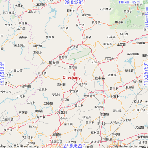
Cheshang GPS coordinates[2]
28° 25' 34.932" North, 114° 33' 16.056" East
| Map corner | latitude | longitude |
|---|---|---|
| Upper-left | 29.0429°, | 113.85134° |
| Center: | 28.42637°, | 114.55446° |
| Lower-right: | 27.80622°, | 115.25759° |
| Map W x H: | 137.5×137.5 km | = 85.4×85.4mi |
| max Lat: | 53.31946° ⇑70.3% North |
| Cheshang: | 28.42637° |
| min Lat: | ⇓29.7% South 18.22056° |
| min Long | Cheshang | max Long |
| 75.07348° | 114.55446° | 134.28917° |
| W 51.9%⇐ | ⇒48.1% E |
Elevation
Elevation of Cheshang is 126 m = 413 ft, and this is 358.8 m = 1177 ft below average elevation for this country.
| Max E: |
5622 m = 18445 ft | 55.7% |
| Avg. | 484.8 m = 1591 ft | |
| Cheshang | 126 m = 413 ft | |
Min E: |
-3 m = -10 ft | 44.3% |
See also: China elevation on elevation.city.
Geographical zone
Cheshang is located in North temperate zone (between Tropic of Cancer and the Arctic Circle). Distance of this Northern Tropic circle is 554.8 km =344.7 mi to South.| Distance of | km | miles | from Cheshang |
|---|---|---|---|
| North Pole | 6846.3 | 4254.1 | to North |
| Arctic Circle | 4240.5 | 2634.9 | to North |
| Tropic Cancer | 554.8 | 344.7 | to South |
| Equator | 3160.7 | 1964 | to South |


Nearby cities:
15 places around Cheshang: (largest is in red/bold)
• Aoqiao
24.6 km =15.3 mi,  96°
96°
• Fangxi
12.2 km =7.6 mi,  137°
137°
• Gaocun
15 km =9.3 mi,  231°
231°
• Huanggang
6.4 km =4 mi,  350°
350°
• Jiaohu
25.1 km =15.6 mi,  221°
221°
• Luocheng
15.5 km =9.6 mi,  180°
180°
• Qiaoxi
21.5 km =13.4 mi, 101°
• Sandu
19.1 km =11.9 mi,  326°
326°
• Sanxing
25.1 km =15.6 mi,  201°
201°
• Shihuajian
5.7 km =3.5 mi, 347°
• Tanshan
23.3 km =14.5 mi,  55°
55°
• Tianbao
23.3 km =14.5 mi, 60°
• Wenquan
23.6 km =14.7 mi,  301°
301°
• Xujiadu
24.7 km =15.3 mi, 144°
• Yongning
21.4 km =13.3 mi, 300°
Sources, notices
• [Note1] Compared only with cities in China existing in our database
• [Src1] Map data: © OpenStreetMap contributors (CC-BY-SA)
• [Src2] Other city data from geonames.org with taken over terms of usage.
• [Src3] Geographical zone / Annual Mean Temperature by Robert A. Rohde @ Wikipedia
