Nanchansi geodata
Nanchansi (Jiangsu) is a seat of a third-order administrative division; located in China in Asia/Shanghai (GMT+8) time zone. In our database, there are 1268 cities with bigger population. Compared to other cities in China, 58.8% of cities are located further ↓South; 83.9% of cities are located further ←West and 92.7% of cities have higher elevation than Nanchansi. Note1


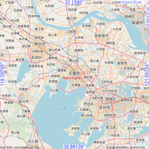
Nanchansi GPS coordinates[2]
31° 33' 44.712" North, 120° 18' 0.756" East
| Map corner | latitude | longitude |
|---|---|---|
| Upper-left | 32.1596°, | 119.59709° |
| Center: | 31.56242°, | 120.30021° |
| Lower-right: | 30.96139°, | 121.00334° |
| Map W x H: | 133.2×133.2 km | = 82.8×82.8mi |
| max Lat: | 53.31946° ⇑41.2% North |
| Nanchansi: | 31.56242° |
| min Lat: | ⇓58.8% South 18.22056° |
| min Long | Nanchansi | max Long |
| 75.07348° | 120.30021° | 134.28917° |
| W 83.9%⇐ | ⇒16.1% E |
Elevation
Elevation of Nanchansi is 8 m = 26 ft, and this is 476.8 m = 1564 ft below average elevation for this country.
| Max E: |
5622 m = 18445 ft | 92.7% |
| Avg. | 484.8 m = 1591 ft | |
| Nanchansi | 8 m = 26 ft | |
Min E: |
-3 m = -10 ft | 7.3% |
See also: China elevation on elevation.city.
Geographical zone
Nanchansi is located in North temperate zone (between Tropic of Cancer and the Arctic Circle). Distance of this Northern Tropic circle is 903.5 km =561.4 mi to South.| Distance of | km | miles | from Nanchansi |
|---|---|---|---|
| North Pole | 6497.6 | 4037.4 | to North |
| Arctic Circle | 3891.8 | 2418.3 | to North |
| Tropic Cancer | 903.5 | 561.4 | to South |
| Equator | 3509.4 | 2180.6 | to South |


Nearby cities:
15 places around Nanchansi: (largest is in red/bold)
• Beidajie
2.7 km =1.7 mi,  339°
339°
• Changjianglu
4 km =2.5 mi,  85°
85°
• Chong’ansi
2 km =1.2 mi,  346°
346°
• Dongbeitang
9.4 km =5.8 mi,  32°
32°
• Fangqian
7.6 km =4.7 mi, 94°
• Helie
4.7 km =2.9 mi,  192°
192°
• Huazhuang
9.7 km =6 mi,  155°
155°
• Lihu
5.4 km =3.4 mi,  220°
220°
• Liutan
6.5 km =4 mi, 353°
• Liyuan
4.2 km =2.6 mi,  240°
240°
• Qianqiao
8.3 km =5.2 mi,  300°
300°
• Rongxiang
6.6 km =4.1 mi,  265°
265°
• Taihu
10.1 km =6.3 mi, 189°
• Wangzhuang
5 km =3.1 mi,  113°
113°
• Wuxi
1.3 km =0.8 mi, 303°
Sources, notices
• [Note1] Compared only with cities in China existing in our database
• [Src1] Map data: © OpenStreetMap contributors (CC-BY-SA)
• [Src2] Other city data from geonames.org with taken over terms of usage.
• [Src3] Geographical zone / Annual Mean Temperature by Robert A. Rohde @ Wikipedia
