Fushou geodata
Fushou (Chongqing) is a seat of a fourth-order administrative division; located in China in Asia/Shanghai (GMT+8) time zone. In our database, there are 1268 cities with bigger population. Compared to other cities in China, 62.4% of cities are located further ↑North; 83.4% of cities are located further →East and 83.5% of cities have lower elevation than Fushou. Note1


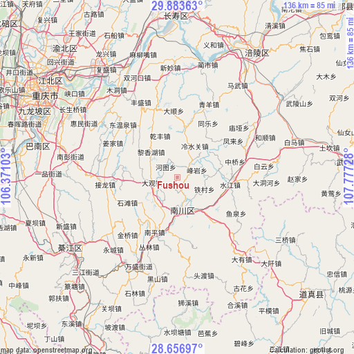
Fushou GPS coordinates[2]
29° 16' 19.704" North, 107° 4' 26.94" East
| Map corner | latitude | longitude |
|---|---|---|
| Upper-left | 29.88363°, | 106.37103° |
| Center: | 29.27214°, | 107.07415° |
| Lower-right: | 28.65697°, | 107.77728° |
| Map W x H: | 136.4×136.4 km | = 84.8×84.8mi |
| max Lat: | 53.31946° ⇑62.4% North |
| Fushou: | 29.27214° |
| min Lat: | ⇓37.6% South 18.22056° |
| min Long | Fushou | max Long |
| 75.07348° | 107.07415° | 134.28917° |
| W 16.6%⇐ | ⇒83.4% E |
Elevation
Elevation of Fushou is 882 m = 2894 ft, and this is 397.2 m = 1303 ft above average elevation for this country.
| Max E: |
5622 m = 18445 ft | 16.5% |
| Fushou | 882 m 2894 ft | |
| Avg. | 484.8 m = 1591 ft | |
Min E: |
-3 m = -10 ft | 83.5% |
See also: China elevation on elevation.city.
Geographical zone
Fushou is located in North temperate zone (between Tropic of Cancer and the Arctic Circle). Distance of this Northern Tropic circle is 648.8 km =403.1 mi to South.| Distance of | km | miles | from Fushou |
|---|---|---|---|
| North Pole | 6752.3 | 4195.7 | to North |
| Arctic Circle | 4146.4 | 2576.5 | to North |
| Tropic Cancer | 648.8 | 403.1 | to South |
| Equator | 3254.8 | 2022.4 | to South |


Nearby cities:
15 places around Fushou: (largest is in red/bold)
• Dongcheng
13.7 km =8.5 mi,  168°
168°
• Fengyan
8 km =5 mi,  69°
69°
• Hetu
6 km =3.7 mi,  312°
312°
• Lengshuiguan
13.9 km =8.6 mi,  29°
29°
• Longtan
19.6 km =12.2 mi,  7°
7°
• Mingyu
5.7 km =3.5 mi,  47°
47°
• Minzhu
13.5 km =8.4 mi,  41°
41°
• Muliang
8 km =5 mi,  218°
218°
• Qilong
17 km =10.6 mi,  57°
57°
• Shentong
17.4 km =10.8 mi,  233°
233°
• Shilong
17.1 km =10.6 mi,  273°
273°
• Shiqiang
12.6 km =7.8 mi,  88°
88°
• Shixi
7.8 km =4.8 mi,  334°
334°
• Tiecun
11.3 km =7 mi,  109°
109°
• Xincun
15 km =9.3 mi,  356°
356°
Sources, notices
• [Note1] Compared only with cities in China existing in our database
• [Src1] Map data: © OpenStreetMap contributors (CC-BY-SA)
• [Src2] Other city data from geonames.org with taken over terms of usage.
• [Src3] Geographical zone / Annual Mean Temperature by Robert A. Rohde @ Wikipedia
