Doushaguan geodata
Doushaguan (Yunnan) is a seat of a fourth-order administrative division; located in China in Asia/Shanghai (GMT+8) time zone. In our database, there are 1268 cities with bigger population. Compared to other cities in China, 73.7% of cities are located further ↑North; 90.1% of cities are located further →East and 89.7% of cities have lower elevation than Doushaguan. Note1


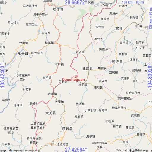
Doushaguan GPS coordinates[2]
28° 2' 52.692" North, 104° 7' 37.74" East
| Map corner | latitude | longitude |
|---|---|---|
| Upper-left | 28.66672°, | 103.42403° |
| Center: | 28.04797°, | 104.12715° |
| Lower-right: | 27.42564°, | 104.83028° |
| Map W x H: | 138×138 km | = 85.7×85.7mi |
| max Lat: | 53.31946° ⇑73.7% North |
| Doushaguan: | 28.04797° |
| min Lat: | ⇓26.3% South 18.22056° |
| min Long | Doushaguan | max Long |
| 75.07348° | 104.12715° | 134.28917° |
| W 9.9%⇐ | ⇒90.1% E |
Elevation
Elevation of Doushaguan is 1339 m = 4393 ft, and this is 854.2 m = 2802 ft above average elevation for this country.
| Max E: |
5622 m = 18445 ft | 10.3% |
| Doushaguan | 1339 m 4393 ft | |
| Avg. | 484.8 m = 1591 ft | |
Min E: |
-3 m = -10 ft | 89.7% |
See also: China elevation on elevation.city.
Geographical zone
Doushaguan is located in North temperate zone (between Tropic of Cancer and the Arctic Circle). Distance of this Northern Tropic circle is 512.7 km =318.6 mi to South.| Distance of | km | miles | from Doushaguan |
|---|---|---|---|
| North Pole | 6888.4 | 4280.3 | to North |
| Arctic Circle | 4282.5 | 2661 | to North |
| Tropic Cancer | 512.7 | 318.6 | to South |
| Equator | 3118.6 | 1937.8 | to South |


Nearby cities:
15 places around Doushaguan: (largest is in red/bold)
• Aitianba
13.8 km =8.6 mi,  16°
16°
• Changping
32.1 km =19.9 mi,  303°
303°
• Chuansiba
30.2 km =18.8 mi,  0°
0°
• Huangjingba
13.2 km =8.2 mi,  253°
253°
• Mugan
20.5 km =12.7 mi,  309°
309°
• Niupizhai
25.9 km =16.1 mi,  74°
74°
• Pu’er
22.8 km =14.2 mi,  9°
9°
• Shangtianba
26.1 km =16.2 mi,  265°
265°
• Shiziba
9.2 km =5.7 mi,  145°
145°
• Tantou
29.5 km =18.3 mi,  27°
27°
• Tianxingchang
26.9 km =16.7 mi,  211°
211°
• Tiexianxi
27.8 km =17.3 mi,  237°
237°
• Xishaqiao
31.6 km =19.6 mi,  333°
333°
• Yanjing
7.7 km =4.8 mi,  60°
60°
• Zhonghechang
12.1 km =7.5 mi,  346°
346°
Sources, notices
• [Note1] Compared only with cities in China existing in our database
• [Src1] Map data: © OpenStreetMap contributors (CC-BY-SA)
• [Src2] Other city data from geonames.org with taken over terms of usage.
• [Src3] Geographical zone / Annual Mean Temperature by Robert A. Rohde @ Wikipedia
