Huayuan geodata
Huayuan (Jiangsu) is a seat of a fourth-order administrative division; located in China in Asia/Shanghai (GMT+8) time zone. In our database, there are 1268 cities with bigger population. Compared to other cities in China, 70.5% of cities are located further ↓South; 78.4% of cities are located further ←West and 98.9% of cities have higher elevation than Huayuan. Note1


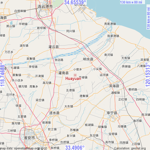
Huayuan GPS coordinates[2]
34° 4' 30" North, 119° 27' 0" East
| Map corner | latitude | longitude |
|---|---|---|
| Upper-left | 34.65539°, | 118.74688° |
| Center: | 34.075°, | 119.45° |
| Lower-right: | 33.4906°, | 120.15313° |
| Map W x H: | 129.5×129.5 km | = 80.5×80.5mi |
| max Lat: | 53.31946° ⇑29.5% North |
| Huayuan: | 34.075° |
| min Lat: | ⇓70.5% South 18.22056° |
| min Long | Huayuan | max Long |
| 75.07348° | 119.45° | 134.28917° |
| W 78.4%⇐ | ⇒21.6% E |
Elevation
Elevation of Huayuan is 3 m = 10 ft, and this is 481.8 m = 1581 ft below average elevation for this country.
| Max E: |
5622 m = 18445 ft | 98.9% |
| Avg. | 484.8 m = 1591 ft | |
| Huayuan | 3 m = 10 ft | |
Min E: |
-3 m = -10 ft | 1.1% |
See also: China elevation on elevation.city.
Geographical zone
Huayuan is located in North temperate zone (between Tropic of Cancer and the Arctic Circle). Distance of this Northern Tropic circle is 1182.9 km =735 mi to South.| Distance of | km | miles | from Huayuan |
|---|---|---|---|
| North Pole | 6218.3 | 3863.9 | to North |
| Arctic Circle | 3612.4 | 2244.6 | to North |
| Tropic Cancer | 1182.9 | 735 | to South |
| Equator | 3788.8 | 2354.3 | to South |


Nearby cities:
15 places around Huayuan: (largest is in red/bold)
• Bailu
7.1 km =4.4 mi,  109°
109°
• Baixian
29.8 km =18.5 mi,  338°
338°
• Changmao
19.5 km =12.1 mi,  36°
36°
• Chenji
13.5 km =8.4 mi,  333°
333°
• Gaogou
24.9 km =15.5 mi,  255°
255°
• Liji
18.5 km =11.5 mi,  280°
280°
• Mengxingzhuang
24.2 km =15 mi,  297°
297°
• Sankou
12.4 km =7.7 mi,  14°
14°
• Shuanggang
29.2 km =18.1 mi, 43°
• Tianlou
23.9 km =14.9 mi, 35°
• Tuhe
30.2 km =18.8 mi,  17°
17°
• Xiaojian
19.5 km =12.1 mi,  70°
70°
• Yunhe
24.6 km =15.3 mi,  87°
87°
• Zhangdian
19.6 km =12.2 mi,  315°
315°
• Zhangji
18.6 km =11.6 mi,  98°
98°
Sources, notices
• [Note1] Compared only with cities in China existing in our database
• [Src1] Map data: © OpenStreetMap contributors (CC-BY-SA)
• [Src2] Other city data from geonames.org with taken over terms of usage.
• [Src3] Geographical zone / Annual Mean Temperature by Robert A. Rohde @ Wikipedia
