Tábor geodata
Tábor (Jihočeský kraj) is a populated place; located in Czech Republic in Europe/Prague (GMT+2) time zone. With population of 36,264 people, there are 29 cities with bigger population in this country. Compared to other cities in Czech Republic, 70.3% of cities are located further ↑North; 67.9% of cities are located further →East and 78.6% of cities have lower elevation than Tábor. Note1


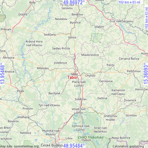
Tábor GPS coordinates[2]
49° 24' 51.876" North, 14° 39' 28.08" East
| Map corner | latitude | longitude |
|---|---|---|
| Upper-left | 49.86972°, | 13.95468° |
| Center: | 49.41441°, | 14.6578° |
| Lower-right: | 48.95484°, | 15.36093° |
| Map W x H: | 101.7×101.7 km | = 63.2×63.2mi |
| max Lat: | 51.01104° ⇑70.3% North |
| Tábor: | 49.41441° |
| min Lat: | ⇓29.7% South 48.60378° |
| min Long | Tábor | max Long |
| 12.17577° | 14.6578° | 18.82683° |
| W 32.1%⇐ | ⇒67.9% E |
Elevation
Elevation of Tábor is 456 m = 1496 ft, and this is 104 m = 341 ft above average elevation for this country.
| Max E: |
901 m = 2956 ft | 21.4% |
| Tábor | 456 m 1496 ft | |
| Avg. | 352 m = 1155 ft | |
Min E: |
136 m = 446 ft | 78.6% |
See also: Czech Republic elevation on elevation.city.
Geographical zone
Tábor is located in North temperate zone (between Tropic of Cancer and the Arctic Circle). Distance of this North polar circle is 1906.8 km =1184.8 mi to North.| Distance of | km | miles | from Tábor |
|---|---|---|---|
| North Pole | 4512.7 | 2804.1 | to North |
| Arctic Circle | 1906.8 | 1184.8 | to North |
| Tropic Cancer | 2888.4 | 1794.8 | to South |
| Equator | 5494.4 | 3414.1 | to South |


Nearby cities:
15 places around Tábor: (largest is in red/bold)
• Borotín
10.6 km =6.6 mi,  342°
342°
• Chotoviny
7.2 km =4.5 mi,  11°
11°
• Chýnov
11.1 km =6.9 mi,  94°
94°
• Dolní Hořice
14.1 km =8.8 mi,  80°
80°
• Dražice
5.2 km =3.2 mi,  288°
288°
• Jistebnice
12.3 km =7.6 mi,  310°
310°
• Košice
12 km =7.5 mi,  145°
145°
• Malšice
8 km =5 mi,  225°
225°
• Opařany
12.9 km =8 mi,  261°
261°
• Planá nad Lužnicí
7.4 km =4.6 mi, 154°
• Ratibořské Hory
9.7 km =6 mi,  56°
56°
• Roudná
13 km =8.1 mi,  160°
160°
• Sezimovo Ústí
3.8 km =2.4 mi, 148°
• Stádlec
12.4 km =7.7 mi,  251°
251°
• Želeč
10.7 km =6.6 mi,  184°
184°
Sources, notices
• [Note1] Compared only with cities in Czech Republic existing in our database
• [Src1] Map data: © OpenStreetMap contributors (CC-BY-SA)
• [Src2] Other city data from geonames.org with taken over terms of usage.
• [Src3] Geographical zone / Annual Mean Temperature by Robert A. Rohde @ Wikipedia
