Světlá nad Sázavou geodata
Světlá nad Sázavou (Vysočina) is a populated place; located in Czech Republic in Europe/Prague (GMT+2) time zone. With population of 7,037 people, there are 197 cities with bigger population in this country. Compared to other cities in Czech Republic, 55.8% of cities are located further ↑North; 54.7% of cities are located further →East and 67% of cities have lower elevation than Světlá nad Sázavou. Note1
Administrative division(s):
- Level 1: Vysočina
- Level 2: Okres Havlíčkův Brod
- Level 3: Světlá nad Sázavou


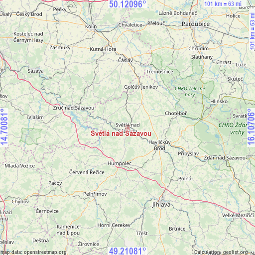
Světlá nad Sázavou GPS coordinates[2]
49° 40' 4.836" North, 15° 24' 14.148" East
| Map corner | latitude | longitude |
|---|---|---|
| Upper-left | 50.12096°, | 14.70081° |
| Center: | 49.66801°, | 15.40393° |
| Lower-right: | 49.21081°, | 16.10706° |
| Map W x H: | 101.2×101.2 km | = 62.9×62.9mi |
| max Lat: | 51.01104° ⇑55.8% North |
| Světlá nad Sázavou: | 49.66801° |
| min Lat: | ⇓44.2% South 48.60378° |
| min Long | Světlá nad S� | max Long |
| 12.17577° | 15.40393° | 18.82683° |
| W 45.3%⇐ | ⇒54.7% E |
Elevation
Elevation of Světlá nad Sázavou is 403 m = 1322 ft, and this is 51 m = 167 ft above average elevation for this country.
| Max E: |
901 m = 2956 ft | 33% |
| Světlá nad Sázavou | 403 m 1322 ft | |
| Avg. | 352 m = 1155 ft | |
Min E: |
136 m = 446 ft | 67% |
See also: Czech Republic elevation on elevation.city.
Geographical zone
Světlá nad Sázavou is located in North temperate zone (between Tropic of Cancer and the Arctic Circle). Distance of this North polar circle is 1878.6 km =1167.3 mi to North.| Distance of | km | miles | from Světlá nad Sázavou |
|---|---|---|---|
| North Pole | 4484.5 | 2786.5 | to North |
| Arctic Circle | 1878.6 | 1167.3 | to North |
| Tropic Cancer | 2916.6 | 1812.3 | to South |
| Equator | 5522.6 | 3431.6 | to South |


Nearby cities:
15 places around Světlá nad Sázavou: (largest is in red/bold)
• Dolní Město
4.7 km =2.9 mi,  199°
199°
• Habry
11.4 km =7.1 mi,  30°
30°
• Havlíčkův Brod
14.3 km =8.9 mi,  118°
118°
• Hněvkovice
14.8 km =9.2 mi,  276°
276°
• Humpolec
14.4 km =8.9 mi,  192°
192°
• Jiřice
14.2 km =8.8 mi,  205°
205°
• Kožlí
10.8 km =6.7 mi,  271°
271°
• Krásná Hora
8.7 km =5.4 mi,  146°
146°
• Ledeč nad Sázavou
9.6 km =6 mi,  288°
288°
• Lipnice nad Sázavou
6.2 km =3.9 mi,  173°
173°
• Lučice
6.7 km =4.2 mi,  95°
95°
• Okrouhlice
7.6 km =4.7 mi, 124°
• Vilémov
14.8 km =9.2 mi, 185°
• Vlkaneč
15.4 km =9.6 mi,  359°
359°
• Věž
12.2 km =7.6 mi,  161°
161°
Sources, notices
• [Note1] Compared only with cities in Czech Republic existing in our database
• [Src1] Map data: © OpenStreetMap contributors (CC-BY-SA)
• [Src2] Other city data from geonames.org with taken over terms of usage.
• [Src3] Geographical zone / Annual Mean Temperature by Robert A. Rohde @ Wikipedia
