Starý Bohumín geodata
Starý Bohumín (Moravskoslezský) is a section of populated place; located in Czech Republic in Europe/Prague (GMT+2) time zone. With population of 23,034 people, there are 60 cities with bigger population in this country. Compared to other cities in Czech Republic, 59.7% of cities are located further ↓South; 97.6% of cities are located further ←West and 90.4% of cities have higher elevation than Starý Bohumín. Note1


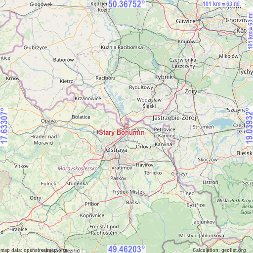
Starý Bohumín GPS coordinates[2]
49° 55' 0.84" North, 18° 20' 10.284" East
| Map corner | latitude | longitude |
|---|---|---|
| Upper-left | 50.36752°, | 17.63307° |
| Center: | 49.9169°, | 18.33619° |
| Lower-right: | 49.46203°, | 19.03932° |
| Map W x H: | 100.7×100.7 km | = 62.6×62.6mi |
| max Lat: | 51.01104° ⇑40.3% North |
| Starý Bohumín: | 49.9169° |
| min Lat: | ⇓59.7% South 48.60378° |
| min Long | Starý Bohumín | max Long |
| 12.17577° | 18.33619° | 18.82683° |
| W 97.6%⇐ | ⇒2.4% E |
Elevation
Elevation of Starý Bohumín is 200 m = 656 ft, and this is 152 m = 499 ft below average elevation for this country.
| Max E: |
901 m = 2956 ft | 90.4% |
| Avg. | 352 m = 1155 ft | |
| Starý Bohumín | 200 m = 656 ft | |
Min E: |
136 m = 446 ft | 9.6% |
See also: Czech Republic elevation on elevation.city.
Geographical zone
Starý Bohumín is located in North temperate zone (between Tropic of Cancer and the Arctic Circle). Distance of this North polar circle is 1850.9 km =1150.1 mi to North.| Distance of | km | miles | from Starý Bohumín |
|---|---|---|---|
| North Pole | 4456.8 | 2769.3 | to North |
| Arctic Circle | 1850.9 | 1150.1 | to North |
| Tropic Cancer | 2944.3 | 1829.5 | to South |
| Equator | 5550.2 | 3448.7 | to South |


Nearby cities:
15 places around Starý Bohumín: (largest is in red/bold)
• Bohumín
2.1 km =1.3 mi,  132°
132°
• Darkovice
8.4 km =5.2 mi,  284°
284°
• Dolní Lutyně
6.9 km =4.3 mi,  107°
107°
• Dětmarovice
9.3 km =5.8 mi, 105°
• Hať
7.7 km =4.8 mi,  295°
295°
• Hlučín
10.5 km =6.5 mi,  258°
258°
• Ludgeřovice
7.5 km =4.7 mi,  246°
246°
• Markvartovice
7.3 km =4.5 mi, 260°
• Orlová
10.4 km =6.5 mi,  139°
139°
• Ostrava
9.9 km =6.2 mi,  202°
202°
• Petřvald
10.3 km =6.4 mi,  158°
158°
• Rychvald
6.3 km =3.9 mi,  152°
152°
• Vrbice
4 km =2.5 mi, 200°
• Vřesina
10.9 km =6.8 mi,  287°
287°
• Šilheřovice
4.8 km =3 mi, 282°
Sources, notices
• [Note1] Compared only with cities in Czech Republic existing in our database
• [Src1] Map data: © OpenStreetMap contributors (CC-BY-SA)
• [Src2] Other city data from geonames.org with taken over terms of usage.
• [Src3] Geographical zone / Annual Mean Temperature by Robert A. Rohde @ Wikipedia
