Stará Huť geodata
Stará Huť (Central Bohemia) is a populated place; located in Czech Republic in Europe/Prague (GMT+2) time zone. With population of 1,158 people, there are 1116 cities with bigger population in this country. Compared to other cities in Czech Republic, 51% of cities are located further ↓South; 79.8% of cities are located further →East and 54% of cities have lower elevation than Stará Huť. Note1


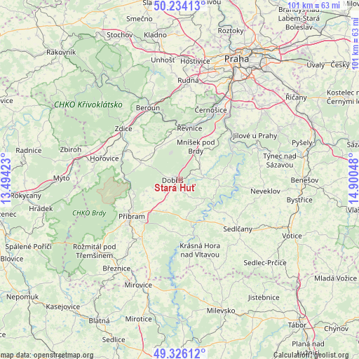
Stará Huť GPS coordinates[2]
49° 46' 56.1" North, 14° 11' 50.46" East
| Map corner | latitude | longitude |
|---|---|---|
| Upper-left | 50.23413°, | 13.49423° |
| Center: | 49.78225°, | 14.19735° |
| Lower-right: | 49.32612°, | 14.90048° |
| Map W x H: | 101×101 km | = 62.8×62.8mi |
| max Lat: | 51.01104° ⇑49% North |
| Stará Huť: | 49.78225° |
| min Lat: | ⇓51% South 48.60378° |
| min Long | Stará Huť | max Long |
| 12.17577° | 14.19735° | 18.82683° |
| W 20.2%⇐ | ⇒79.8% E |
Elevation
Elevation of Stará Huť is 353 m = 1158 ft, and this is 1 m = 3 ft above average elevation for this country.
| Max E: |
901 m = 2956 ft | 46% |
| Stará Huť | 353 m 1158 ft | |
| Avg. | 352 m = 1155 ft | |
Min E: |
136 m = 446 ft | 54% |
See also: Czech Republic elevation on elevation.city.
Geographical zone
Stará Huť is located in North temperate zone (between Tropic of Cancer and the Arctic Circle). Distance of this North polar circle is 1865.9 km =1159.4 mi to North.| Distance of | km | miles | from Stará Huť |
|---|---|---|---|
| North Pole | 4471.8 | 2778.6 | to North |
| Arctic Circle | 1865.9 | 1159.4 | to North |
| Tropic Cancer | 2929.3 | 1820.2 | to South |
| Equator | 5535.3 | 3439.5 | to South |


Nearby cities:
15 places around Stará Huť: (largest is in red/bold)
• Dobříš
2.2 km =1.4 mi,  266°
266°
• Hluboš
13.3 km =8.3 mi,  252°
252°
• Hostomice
11.9 km =7.4 mi,  293°
293°
• Liteň
13.9 km =8.6 mi,  345°
345°
• Malá Hraštice
6.6 km =4.1 mi,  64°
64°
• Mníšek pod Brdy
10.4 km =6.5 mi,  26°
26°
• Neumětely
13.9 km =8.6 mi,  304°
304°
• Nečín
9.7 km =6 mi,  164°
164°
• Nová Ves pod Pleší
7.8 km =4.8 mi,  45°
45°
• Nový Knín
6.9 km =4.3 mi,  84°
84°
• Obořiště
5.5 km =3.4 mi,  216°
216°
• Pičín
10.8 km =6.7 mi, 247°
• Rosovice
7 km =4.3 mi, 245°
• Višňová
9.3 km =5.8 mi,  203°
203°
• Čisovice
12.3 km =7.6 mi,  43°
43°
Sources, notices
• [Note1] Compared only with cities in Czech Republic existing in our database
• [Src1] Map data: © OpenStreetMap contributors (CC-BY-SA)
• [Src2] Other city data from geonames.org with taken over terms of usage.
• [Src3] Geographical zone / Annual Mean Temperature by Robert A. Rohde @ Wikipedia
