Rotava geodata
Rotava (Karlovarský kraj) is a populated place; located in Czech Republic in Europe/Prague (GMT+2) time zone. With population of 3,403 people, there are 392 cities with bigger population in this country. Compared to other cities in Czech Republic, 83.3% of cities are located further ↓South; 99.2% of cities are located further →East and 87.7% of cities have lower elevation than Rotava. Note1


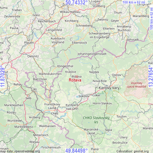
Rotava GPS coordinates[2]
50° 17' 46.572" North, 12° 34' 24.276" East
| Map corner | latitude | longitude |
|---|---|---|
| Upper-left | 50.74332°, | 11.87029° |
| Center: | 50.29627°, | 12.57341° |
| Lower-right: | 49.84498°, | 13.27654° |
| Map W x H: | 99.9×99.9 km | = 62.1×62.1mi |
| max Lat: | 51.01104° ⇑16.7% North |
| Rotava: | 50.29627° |
| min Lat: | ⇓83.3% South 48.60378° |
| min Long | Rotava | max Long |
| 12.17577° | 12.57341° | 18.82683° |
| W 0.8%⇐ | ⇒99.2% E |
Elevation
Elevation of Rotava is 515 m = 1690 ft, and this is 163 m = 535 ft above average elevation for this country.
| Max E: |
901 m = 2956 ft | 12.3% |
| Rotava | 515 m 1690 ft | |
| Avg. | 352 m = 1155 ft | |
Min E: |
136 m = 446 ft | 87.7% |
See also: Czech Republic elevation on elevation.city.
Geographical zone
Rotava is located in North temperate zone (between Tropic of Cancer and the Arctic Circle). Distance of this North polar circle is 1808.8 km =1123.9 mi to North.| Distance of | km | miles | from Rotava |
|---|---|---|---|
| North Pole | 4414.6 | 2743.1 | to North |
| Arctic Circle | 1808.8 | 1123.9 | to North |
| Tropic Cancer | 2986.5 | 1855.7 | to South |
| Equator | 5592.4 | 3475 | to South |


Nearby cities:
15 places around Rotava: (largest is in red/bold)
• Bukovany
14.4 km =8.9 mi,  180°
180°
• Chodov
13.7 km =8.5 mi,  117°
117°
• Habartov
12.7 km =7.9 mi,  187°
187°
• Krajková
9.4 km =5.8 mi,  197°
197°
• Kraslice
5 km =3.1 mi,  307°
307°
• Královské Poříčí
13.7 km =8.5 mi,  146°
146°
• Lomnice
10.3 km =6.4 mi,  155°
155°
• Luby
12.9 km =8 mi,  247°
247°
• Nejdek
11.4 km =7.1 mi,  75°
75°
• Nový Kostel
12.7 km =7.9 mi,  225°
225°
• Oloví
5.1 km =3.2 mi, 191°
• Sokolov
13.6 km =8.5 mi, 159°
• Svatava
12.1 km =7.5 mi, 162°
• Vintířov
12.4 km =7.7 mi, 124°
• Vřesová
9.7 km =6 mi, 115°
Sources, notices
• [Note1] Compared only with cities in Czech Republic existing in our database
• [Src1] Map data: © OpenStreetMap contributors (CC-BY-SA)
• [Src2] Other city data from geonames.org with taken over terms of usage.
• [Src3] Geographical zone / Annual Mean Temperature by Robert A. Rohde @ Wikipedia
