Radslavice geodata
Radslavice (Olomoucký) is a populated place; located in Czech Republic in Europe/Prague (GMT+2) time zone. With population of 1,110 people, there are 1166 cities with bigger population in this country. Compared to other cities in Czech Republic, 66.9% of cities are located further ↑North; 85.4% of cities are located further ←West and 82.3% of cities have higher elevation than Radslavice. Note1


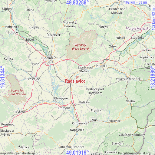
Radslavice GPS coordinates[2]
49° 28' 41.412" North, 17° 30' 59.616" East
| Map corner | latitude | longitude |
|---|---|---|
| Upper-left | 49.93289°, | 16.81344° |
| Center: | 49.47817°, | 17.51656° |
| Lower-right: | 49.01919°, | 18.21969° |
| Map W x H: | 101.6×101.6 km | = 63.1×63.1mi |
| max Lat: | 51.01104° ⇑66.9% North |
| Radslavice: | 49.47817° |
| min Lat: | ⇓33.1% South 48.60378° |
| min Long | Radslavice | max Long |
| 12.17577° | 17.51656° | 18.82683° |
| W 85.4%⇐ | ⇒14.6% E |
Elevation
Elevation of Radslavice is 224 m = 735 ft, and this is 128 m = 420 ft below average elevation for this country.
| Max E: |
901 m = 2956 ft | 82.3% |
| Avg. | 352 m = 1155 ft | |
| Radslavice | 224 m = 735 ft | |
Min E: |
136 m = 446 ft | 17.7% |
See also: Czech Republic elevation on elevation.city.
Geographical zone
Radslavice is located in North temperate zone (between Tropic of Cancer and the Arctic Circle). Distance of this North polar circle is 1899.7 km =1180.4 mi to North.| Distance of | km | miles | from Radslavice |
|---|---|---|---|
| North Pole | 4505.6 | 2799.6 | to North |
| Arctic Circle | 1899.7 | 1180.4 | to North |
| Tropic Cancer | 2895.5 | 1799.2 | to South |
| Equator | 5501.5 | 3418.5 | to South |


Nearby cities:
15 places around Radslavice: (largest is in red/bold)
• Beňov
6.9 km =4.3 mi,  189°
189°
• Bochoř
9 km =5.6 mi,  225°
225°
• Dolní Újezd
7.7 km =4.8 mi,  10°
10°
• Dřevohostice
8 km =5 mi,  136°
136°
• Horní Moštěnice
8.4 km =5.2 mi,  209°
209°
• Lipník nad Bečvou
7.4 km =4.6 mi,  42°
42°
• Osek nad Bečvou
3.8 km =2.4 mi, 12°
• Pavlovice u Přerova
2.5 km =1.6 mi,  113°
113°
• Přerov
5.4 km =3.4 mi,  241°
241°
• Rokytnice
9.2 km =5.7 mi,  261°
261°
• Soběchleby
9.8 km =6.1 mi,  89°
89°
• Tršice
9.7 km =6 mi,  317°
317°
• Týn nad Bečvou
8.5 km =5.3 mi,  59°
59°
• Veselíčko
5.8 km =3.6 mi,  350°
350°
• Želatovice
3.9 km =2.4 mi, 191°
Sources, notices
• [Note1] Compared only with cities in Czech Republic existing in our database
• [Src1] Map data: © OpenStreetMap contributors (CC-BY-SA)
• [Src2] Other city data from geonames.org with taken over terms of usage.
• [Src3] Geographical zone / Annual Mean Temperature by Robert A. Rohde @ Wikipedia
