Prostějov geodata
Prostějov (Olomoucký) is a populated place; located in Czech Republic in Europe/Prague (GMT+2) time zone. With population of 47,374 people, there are 22 cities with bigger population in this country. Compared to other cities in Czech Republic, 67.3% of cities are located further ↑North; 78.1% of cities are located further ←West and 81.3% of cities have higher elevation than Prostějov. Note1


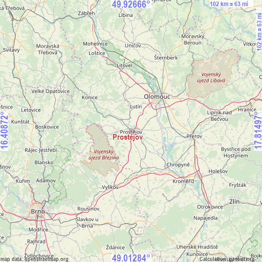
Prostějov GPS coordinates[2]
49° 28' 18.768" North, 17° 6' 42.624" East
| Map corner | latitude | longitude |
|---|---|---|
| Upper-left | 49.92666°, | 16.40872° |
| Center: | 49.47188°, | 17.11184° |
| Lower-right: | 49.01284°, | 17.81497° |
| Map W x H: | 101.6×101.6 km | = 63.1×63.1mi |
| max Lat: | 51.01104° ⇑67.3% North |
| Prostějov: | 49.47188° |
| min Lat: | ⇓32.7% South 48.60378° |
| min Long | Prostějov | max Long |
| 12.17577° | 17.11184° | 18.82683° |
| W 78.1%⇐ | ⇒21.9% E |
Elevation
Elevation of Prostějov is 227 m = 745 ft, and this is 125 m = 410 ft below average elevation for this country.
| Max E: |
901 m = 2956 ft | 81.3% |
| Avg. | 352 m = 1155 ft | |
| Prostějov | 227 m = 745 ft | |
Min E: |
136 m = 446 ft | 18.7% |
See also: Prostějov elevation on elevation.city.
Geographical zone
Prostějov is located in North temperate zone (between Tropic of Cancer and the Arctic Circle). Distance of this North polar circle is 1900.4 km =1180.9 mi to North.| Distance of | km | miles | from Prostějov |
|---|---|---|---|
| North Pole | 4506.3 | 2800.1 | to North |
| Arctic Circle | 1900.4 | 1180.9 | to North |
| Tropic Cancer | 2894.8 | 1798.7 | to South |
| Equator | 5500.8 | 3418 | to South |


Nearby cities:
15 places around Prostějov: (largest is in red/bold)
• Bedihošť
4.7 km =2.9 mi,  123°
123°
• Bystročice
9.3 km =5.8 mi,  39°
39°
• Hrubčice
6.4 km =4 mi,  112°
112°
• Kostelec na Hané
6.1 km =3.8 mi,  320°
320°
• Kralice na Hané
5.1 km =3.2 mi,  101°
101°
• Krumsín
8.5 km =5.3 mi,  250°
250°
• Mostkovice
4.3 km =2.7 mi,  270°
270°
• Plumlov
7 km =4.3 mi,  264°
264°
• Smržice
3.8 km =2.4 mi,  354°
354°
• Stařechovice
8 km =5 mi,  328°
328°
• Určice
5.4 km =3.4 mi,  211°
211°
• Vrbátky
7.5 km =4.7 mi,  57°
57°
• Čehovice
6.3 km =3.9 mi,  133°
133°
• Čelechovice na Hané
5.1 km =3.2 mi, 345°
• Čelčice
8.9 km =5.5 mi,  138°
138°
Sources, notices
• [Note1] Compared only with cities in Czech Republic existing in our database
• [Src1] Map data: © OpenStreetMap contributors (CC-BY-SA)
• [Src2] Other city data from geonames.org with taken over terms of usage.
• [Src3] Geographical zone / Annual Mean Temperature by Robert A. Rohde @ Wikipedia
