Okrouhlá geodata
Okrouhlá (South Moravian) is a populated place; located in Czech Republic in Europe/Prague (GMT+2) time zone. With population of 523 people, there are 2408 cities with bigger population in this country. Compared to other cities in Czech Republic, 65.6% of cities are located further ↑North; 69.7% of cities are located further ←West and 95.3% of cities have lower elevation than Okrouhlá. Note1


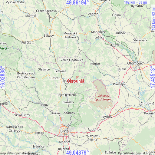
Okrouhlá GPS coordinates[2]
49° 30' 27" North, 16° 43' 55.2" East
| Map corner | latitude | longitude |
|---|---|---|
| Upper-left | 49.96194°, | 16.02888° |
| Center: | 49.5075°, | 16.732° |
| Lower-right: | 49.04879°, | 17.43513° |
| Map W x H: | 101.5×101.5 km | = 63.1×63.1mi |
| max Lat: | 51.01104° ⇑65.6% North |
| Okrouhlá: | 49.5075° |
| min Lat: | ⇓34.4% South 48.60378° |
| min Long | Okrouhlá | max Long |
| 12.17577° | 16.732° | 18.82683° |
| W 69.7%⇐ | ⇒30.3% E |
Elevation
Elevation of Okrouhlá is 587 m = 1926 ft, and this is 235 m = 771 ft above average elevation for this country.
| Max E: |
901 m = 2956 ft | 4.7% |
| Okrouhlá | 587 m 1926 ft | |
| Avg. | 352 m = 1155 ft | |
Min E: |
136 m = 446 ft | 95.3% |
See also: Czech Republic elevation on elevation.city.
Geographical zone
Okrouhlá is located in North temperate zone (between Tropic of Cancer and the Arctic Circle). Distance of this North polar circle is 1896.5 km =1178.4 mi to North.| Distance of | km | miles | from Okrouhlá |
|---|---|---|---|
| North Pole | 4502.3 | 2797.6 | to North |
| Arctic Circle | 1896.5 | 1178.4 | to North |
| Tropic Cancer | 2898.8 | 1801.2 | to South |
| Equator | 5504.7 | 3420.5 | to South |


Nearby cities:
15 places around Okrouhlá: (largest is in red/bold)
• Benešov
2.8 km =1.7 mi,  85°
85°
• Boskovice
5.7 km =3.5 mi,  246°
246°
• Brodek u Konice
8.6 km =5.3 mi,  57°
57°
• Cetkovice
8 km =5 mi,  354°
354°
• Horní Štěpánov
6.3 km =3.9 mi,  42°
42°
• Knínice u Boskovic
4.5 km =2.8 mi,  323°
323°
• Lipová
9.6 km =6 mi,  77°
77°
• Protivanov
8 km =5 mi,  109°
109°
• Sebranice
10.5 km =6.5 mi,  262°
262°
• Skalice nad Svitavou
9.7 km =6 mi, 252°
• Sloup
10.3 km =6.4 mi,  176°
176°
• Svitávka
9.7 km =6 mi,  266°
266°
• Vanovice
8.2 km =5.1 mi, 324°
• Šebetov
4.8 km =3 mi,  342°
342°
• Žďárná
4.7 km =2.9 mi,  156°
156°
Sources, notices
• [Note1] Compared only with cities in Czech Republic existing in our database
• [Src1] Map data: © OpenStreetMap contributors (CC-BY-SA)
• [Src2] Other city data from geonames.org with taken over terms of usage.
• [Src3] Geographical zone / Annual Mean Temperature by Robert A. Rohde @ Wikipedia
