Lázně Bělohrad geodata
Lázně Bělohrad (Královéhradecký kraj) is a populated place; located in Czech Republic in Europe/Prague (GMT+2) time zone. With population of 3,744 people, there are 360 cities with bigger population in this country. Compared to other cities in Czech Republic, 88.2% of cities are located further ↓South; 51.9% of cities are located further →East and 58.4% of cities have higher elevation than Lázně Bělohrad. Note1
Administrative division(s):
- Level 1: Královéhradecký kraj
- Level 2: Okres Jičín
- Level 3: Lázně Bělohrad


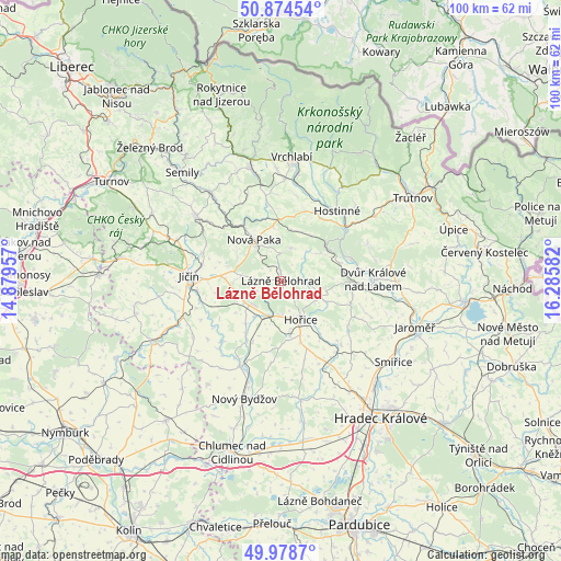
Lázně Bělohrad GPS coordinates[2]
50° 25' 43.464" North, 15° 34' 57.684" East
| Map corner | latitude | longitude |
|---|---|---|
| Upper-left | 50.87454°, | 14.87957° |
| Center: | 50.42874°, | 15.58269° |
| Lower-right: | 49.9787°, | 16.28582° |
| Map W x H: | 99.6×99.6 km | = 61.9×61.9mi |
| max Lat: | 51.01104° ⇑11.8% North |
| Lázně Bělohrad: | 50.42874° |
| min Lat: | ⇓88.2% South 48.60378° |
| min Long | Lázně Bělohr | max Long |
| 12.17577° | 15.58269° | 18.82683° |
| W 48.1%⇐ | ⇒51.9% E |
Elevation
Elevation of Lázně Bělohrad is 300 m = 984 ft, and this is 52 m = 171 ft below average elevation for this country.
| Max E: |
901 m = 2956 ft | 58.4% |
| Avg. | 352 m = 1155 ft | |
| Lázně Bělohrad | 300 m = 984 ft | |
Min E: |
136 m = 446 ft | 41.6% |
See also: Czech Republic elevation on elevation.city.
Geographical zone
Lázně Bělohrad is located in North temperate zone (between Tropic of Cancer and the Arctic Circle). Distance of this North polar circle is 1794 km =1114.7 mi to North.| Distance of | km | miles | from Lázně Bělohrad |
|---|---|---|---|
| North Pole | 4399.9 | 2734 | to North |
| Arctic Circle | 1794 | 1114.7 | to North |
| Tropic Cancer | 3001.2 | 1864.9 | to South |
| Equator | 5607.2 | 3484.2 | to South |


Nearby cities:
15 places around Lázně Bělohrad: (largest is in red/bold)
• Bílá Třemešná
11.4 km =7.1 mi,  81°
81°
• Chomutice
9.9 km =6.2 mi,  218°
218°
• Dolní Kalná
12.9 km =8 mi,  18°
18°
• Hořice
7.8 km =4.8 mi,  153°
153°
• Lužany
8 km =5 mi,  271°
271°
• Miletín
7.6 km =4.7 mi,  111°
111°
• Mlázovice
4.7 km =2.9 mi,  246°
246°
• Mostek
10.3 km =6.4 mi,  51°
51°
• Nemojov
12.9 km =8 mi,  71°
71°
• Nová Paka
8.7 km =5.4 mi,  326°
326°
• Ostroměř
6.7 km =4.2 mi,  200°
200°
• Pecka
6 km =3.7 mi, 17°
• Stará Paka
11 km =6.8 mi, 325°
• Studenec
14.1 km =8.8 mi,  350°
350°
• Zadní Mostek
11.1 km =6.9 mi, 47°
Sources, notices
• [Note1] Compared only with cities in Czech Republic existing in our database
• [Src1] Map data: © OpenStreetMap contributors (CC-BY-SA)
• [Src2] Other city data from geonames.org with taken over terms of usage.
• [Src3] Geographical zone / Annual Mean Temperature by Robert A. Rohde @ Wikipedia
