Kutná Hora geodata
Kutná Hora (Central Bohemia) is a populated place; located in Czech Republic in Europe/Prague (GMT+2) time zone. With population of 21,280 people, there are 64 cities with bigger population in this country. Compared to other cities in Czech Republic, 62.3% of cities are located further ↓South; 57.3% of cities are located further →East and 70.8% of cities have higher elevation than Kutná Hora. Note1


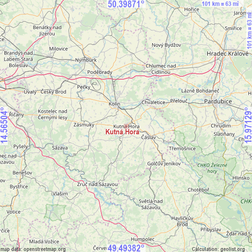
Kutná Hora GPS coordinates[2]
49° 56' 54.204" North, 15° 16' 5.376" East
| Map corner | latitude | longitude |
|---|---|---|
| Upper-left | 50.39871°, | 14.56504° |
| Center: | 49.94839°, | 15.26816° |
| Lower-right: | 49.49382°, | 15.97129° |
| Map W x H: | 100.6×100.6 km | = 62.5×62.5mi |
| max Lat: | 51.01104° ⇑37.7% North |
| Kutná Hora: | 49.94839° |
| min Lat: | ⇓62.3% South 48.60378° |
| min Long | Kutná Hora | max Long |
| 12.17577° | 15.26816° | 18.82683° |
| W 42.7%⇐ | ⇒57.3% E |
Elevation
Elevation of Kutná Hora is 255 m = 837 ft, and this is 97 m = 318 ft below average elevation for this country.
| Max E: |
901 m = 2956 ft | 70.8% |
| Avg. | 352 m = 1155 ft | |
| Kutná Hora | 255 m = 837 ft | |
Min E: |
136 m = 446 ft | 29.2% |
See also: Czech Republic elevation on elevation.city.
Geographical zone
Kutná Hora is located in North temperate zone (between Tropic of Cancer and the Arctic Circle). Distance of this North polar circle is 1847.4 km =1147.9 mi to North.| Distance of | km | miles | from Kutná Hora |
|---|---|---|---|
| North Pole | 4453.3 | 2767.2 | to North |
| Arctic Circle | 1847.4 | 1147.9 | to North |
| Tropic Cancer | 2947.8 | 1831.7 | to South |
| Equator | 5553.7 | 3450.9 | to South |


Nearby cities:
15 places around Kutná Hora: (largest is in red/bold)
• Chlístovice
8.4 km =5.2 mi,  214°
214°
• Chotusice
9 km =5.6 mi,  89°
89°
• Církvice
4.8 km =3 mi, 93°
• Křesetice
4.6 km =2.9 mi,  184°
184°
• Malešov
5.2 km =3.2 mi,  217°
217°
• Miskovice
4.5 km =2.8 mi,  266°
266°
• Nové Dvory
4.8 km =3 mi,  62°
62°
• Polepy
7.7 km =4.8 mi,  324°
324°
• Ratboř
8.5 km =5.3 mi,  292°
292°
• Sedlec
2.3 km =1.4 mi,  40°
40°
• Starý Kolín
7.1 km =4.4 mi,  15°
15°
• Suchdol
7.3 km =4.5 mi, 273°
• Svatý Mikuláš
7.6 km =4.7 mi,  51°
51°
• Tři Dvory
9.3 km =5.8 mi,  354°
354°
• Červené Pečky
5.4 km =3.4 mi,  307°
307°
Sources, notices
• [Note1] Compared only with cities in Czech Republic existing in our database
• [Src1] Map data: © OpenStreetMap contributors (CC-BY-SA)
• [Src2] Other city data from geonames.org with taken over terms of usage.
• [Src3] Geographical zone / Annual Mean Temperature by Robert A. Rohde @ Wikipedia
