Kostelní Lhota geodata
Kostelní Lhota (Central Bohemia) is a populated place; located in Czech Republic in Europe/Prague (GMT+2) time zone. With population of 742 people, there are 1728 cities with bigger population in this country. Compared to other cities in Czech Republic, 73.9% of cities are located further ↓South; 61.9% of cities are located further →East and 94.5% of cities have higher elevation than Kostelní Lhota. Note1


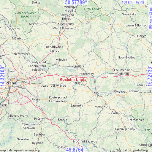
Kostelní Lhota GPS coordinates[2]
50° 7' 45.372" North, 15° 1' 27.12" East
| Map corner | latitude | longitude |
|---|---|---|
| Upper-left | 50.57789°, | 14.32108° |
| Center: | 50.12927°, | 15.0242° |
| Lower-right: | 49.6764°, | 15.72733° |
| Map W x H: | 100.2×100.2 km | = 62.3×62.3mi |
| max Lat: | 51.01104° ⇑26.1% North |
| Kostelní Lhota: | 50.12927° |
| min Lat: | ⇓73.9% South 48.60378° |
| min Long | Kostelní Lhota | max Long |
| 12.17577° | 15.0242° | 18.82683° |
| W 38.1%⇐ | ⇒61.9% E |
Elevation
Elevation of Kostelní Lhota is 188 m = 617 ft, and this is 164 m = 538 ft below average elevation for this country.
| Max E: |
901 m = 2956 ft | 94.5% |
| Avg. | 352 m = 1155 ft | |
| Kostelní Lhota | 188 m = 617 ft | |
Min E: |
136 m = 446 ft | 5.5% |
See also: Czech Republic elevation on elevation.city.
Geographical zone
Kostelní Lhota is located in North temperate zone (between Tropic of Cancer and the Arctic Circle). Distance of this North polar circle is 1827.3 km =1135.4 mi to North.| Distance of | km | miles | from Kostelní Lhota |
|---|---|---|---|
| North Pole | 4433.2 | 2754.7 | to North |
| Arctic Circle | 1827.3 | 1135.4 | to North |
| Tropic Cancer | 2967.9 | 1844.2 | to South |
| Equator | 5573.9 | 3463.5 | to South |


Nearby cities:
15 places around Kostelní Lhota: (largest is in red/bold)
• Cerhenice
7.3 km =4.5 mi,  152°
152°
• Dobřichov
5.6 km =3.5 mi,  173°
173°
• Hořátev
2.5 km =1.6 mi,  26°
26°
• Kamenné Zboží
7.3 km =4.5 mi,  345°
345°
• Kovanice
5.6 km =3.5 mi,  36°
36°
• Nymburk
6.4 km =4 mi,  11°
11°
• Pečky
4.3 km =2.7 mi, 174°
• Poděbrady
6.9 km =4.3 mi,  77°
77°
• Poříčany
7.9 km =4.9 mi,  252°
252°
• Radím
6.6 km =4.1 mi,  187°
187°
• Ratenice
4.9 km =3 mi, 149°
• Sadská
2.8 km =1.7 mi,  285°
285°
• Sokoleč
6.8 km =4.2 mi,  120°
120°
• Tatce
5.4 km =3.4 mi,  218°
218°
• Třebestovice
4.7 km =2.9 mi,  263°
263°
Sources, notices
• [Note1] Compared only with cities in Czech Republic existing in our database
• [Src1] Map data: © OpenStreetMap contributors (CC-BY-SA)
• [Src2] Other city data from geonames.org with taken over terms of usage.
• [Src3] Geographical zone / Annual Mean Temperature by Robert A. Rohde @ Wikipedia
