Konopiště geodata
Konopiště (Central Bohemia) is a populated place; located in Czech Republic in Europe/Prague (GMT+2) time zone. With population of 876 people, there are 1464 cities with bigger population in this country. Compared to other cities in Czech Republic, 51% of cities are located further ↓South; 67.9% of cities are located further →East and 50.7% of cities have lower elevation than Konopiště. Note1


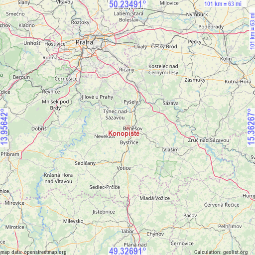
Konopiště GPS coordinates[2]
49° 46' 58.944" North, 14° 39' 34.344" East
| Map corner | latitude | longitude |
|---|---|---|
| Upper-left | 50.23491°, | 13.95642° |
| Center: | 49.78304°, | 14.65954° |
| Lower-right: | 49.32691°, | 15.36267° |
| Map W x H: | 101×101 km | = 62.8×62.8mi |
| max Lat: | 51.01104° ⇑49% North |
| Konopiště: | 49.78304° |
| min Lat: | ⇓51% South 48.60378° |
| min Long | Konopiště | max Long |
| 12.17577° | 14.65954° | 18.82683° |
| W 32.1%⇐ | ⇒67.9% E |
Elevation
Elevation of Konopiště is 338 m = 1109 ft, and this is 14 m = 46 ft below average elevation for this country.
| Max E: |
901 m = 2956 ft | 49.3% |
| Avg. | 352 m = 1155 ft | |
| Konopiště | 338 m = 1109 ft | |
Min E: |
136 m = 446 ft | 50.7% |
See also: Czech Republic elevation on elevation.city.
Geographical zone
Konopiště is located in North temperate zone (between Tropic of Cancer and the Arctic Circle). Distance of this North polar circle is 1865.8 km =1159.4 mi to North.| Distance of | km | miles | from Konopiště |
|---|---|---|---|
| North Pole | 4471.7 | 2778.6 | to North |
| Arctic Circle | 1865.8 | 1159.4 | to North |
| Tropic Cancer | 2929.4 | 1820.2 | to South |
| Equator | 5535.4 | 3439.5 | to South |


Nearby cities:
15 places around Konopiště: (largest is in red/bold)
• Benešov
2 km =1.2 mi,  94°
94°
• Bukovany
5.1 km =3.2 mi,  330°
330°
• Bystřice
5.7 km =3.5 mi,  174°
174°
• Krhanice
10.9 km =6.8 mi,  317°
317°
• Lešany
11.8 km =7.3 mi,  305°
305°
• Maršovice
10.3 km =6.4 mi,  221°
221°
• Mrač
5.6 km =3.5 mi,  23°
23°
• Netvořice
10.8 km =6.7 mi,  289°
289°
• Neveklov
9.7 km =6 mi,  250°
250°
• Postupice
10.4 km =6.5 mi,  125°
125°
• Poříčí nad Sázavou
6.3 km =3.9 mi,  9°
9°
• Pyšely
10.5 km =6.5 mi, 6°
• Struhařov
7.6 km =4.7 mi,  104°
104°
• Týnec nad Sázavou
7.5 km =4.7 mi, 318°
• Čerčany
8.4 km =5.2 mi, 21°
Sources, notices
• [Note1] Compared only with cities in Czech Republic existing in our database
• [Src1] Map data: © OpenStreetMap contributors (CC-BY-SA)
• [Src2] Other city data from geonames.org with taken over terms of usage.
• [Src3] Geographical zone / Annual Mean Temperature by Robert A. Rohde @ Wikipedia
