Kateřinice geodata
Kateřinice (Moravskoslezský) is a populated place; located in Czech Republic in Europe/Prague (GMT+2) time zone. With population of 608 people, there are 2098 cities with bigger population in this country. Compared to other cities in Czech Republic, 55.7% of cities are located further ↑North; 96.2% of cities are located further ←West and 69.3% of cities have higher elevation than Kateřinice. Note1


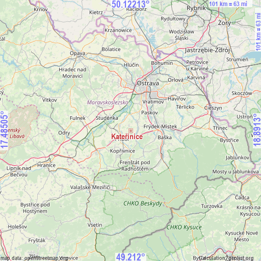
Kateřinice GPS coordinates[2]
49° 40' 9.084" North, 18° 11' 17.412" East
| Map corner | latitude | longitude |
|---|---|---|
| Upper-left | 50.12213°, | 17.48505° |
| Center: | 49.66919°, | 18.18817° |
| Lower-right: | 49.212°, | 18.8913° |
| Map W x H: | 101.2×101.2 km | = 62.9×62.9mi |
| max Lat: | 51.01104° ⇑55.7% North |
| Kateřinice: | 49.66919° |
| min Lat: | ⇓44.3% South 48.60378° |
| min Long | Kateřinice | max Long |
| 12.17577° | 18.18817° | 18.82683° |
| W 96.2%⇐ | ⇒3.8% E |
Elevation
Elevation of Kateřinice is 259 m = 850 ft, and this is 93 m = 305 ft below average elevation for this country.
| Max E: |
901 m = 2956 ft | 69.3% |
| Avg. | 352 m = 1155 ft | |
| Kateřinice | 259 m = 850 ft | |
Min E: |
136 m = 446 ft | 30.7% |
See also: Czech Republic elevation on elevation.city.
Geographical zone
Kateřinice is located in North temperate zone (between Tropic of Cancer and the Arctic Circle). Distance of this North polar circle is 1878.5 km =1167.2 mi to North.| Distance of | km | miles | from Kateřinice |
|---|---|---|---|
| North Pole | 4484.4 | 2786.5 | to North |
| Arctic Circle | 1878.5 | 1167.2 | to North |
| Tropic Cancer | 2916.8 | 1812.4 | to South |
| Equator | 5522.7 | 3431.6 | to South |


Nearby cities:
15 places around Kateřinice: (largest is in red/bold)
• Albrechtičky
7.6 km =4.7 mi,  298°
298°
• Brušperk
4.2 km =2.6 mi,  35°
35°
• Fryčovice
2.5 km =1.6 mi,  96°
96°
• Hukvaldy
5.6 km =3.5 mi,  154°
154°
• Kopřivnice
8.4 km =5.2 mi,  201°
201°
• Krmelín
7.5 km =4.7 mi,  27°
27°
• Mošnov
4.6 km =2.9 mi, 298°
• Petřvald
4.9 km =3 mi,  333°
333°
• Příbor
4.4 km =2.7 mi,  224°
224°
• Sedlnice
7.4 km =4.6 mi,  260°
260°
• Stará Ves nad Ondřejnicí
6.5 km =4 mi,  0°
0°
• Staříč
6.4 km =4 mi,  72°
72°
• Trnávka
1.9 km =1.2 mi,  336°
336°
• Závišice
8.7 km =5.4 mi, 224°
• Žabeň
9.4 km =5.8 mi,  62°
62°
Sources, notices
• [Note1] Compared only with cities in Czech Republic existing in our database
• [Src1] Map data: © OpenStreetMap contributors (CC-BY-SA)
• [Src2] Other city data from geonames.org with taken over terms of usage.
• [Src3] Geographical zone / Annual Mean Temperature by Robert A. Rohde @ Wikipedia
