Kamýk nad Vltavou geodata
Kamýk nad Vltavou (Central Bohemia) is a populated place; located in Czech Republic in Europe/Prague (GMT+2) time zone. With population of 821 people, there are 1562 cities with bigger population in this country. Compared to other cities in Czech Republic, 57.5% of cities are located further ↑North; 78.6% of cities are located further →East and 62.8% of cities have higher elevation than Kamýk nad Vltavou. Note1
Administrative division(s):
- Level 1: Central Bohemia
- Level 2: Okres Příbram
- Level 3: Kamýk nad Vltavou


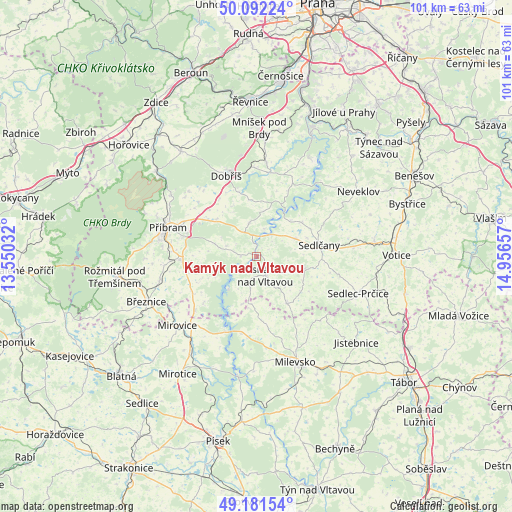
Kamýk nad Vltavou GPS coordinates[2]
49° 38' 20.472" North, 14° 15' 12.384" East
| Map corner | latitude | longitude |
|---|---|---|
| Upper-left | 50.09224°, | 13.55032° |
| Center: | 49.63902°, | 14.25344° |
| Lower-right: | 49.18154°, | 14.95657° |
| Map W x H: | 101.3×101.3 km | = 62.9×62.9mi |
| max Lat: | 51.01104° ⇑57.5% North |
| Kamýk nad Vltavou: | 49.63902° |
| min Lat: | ⇓42.5% South 48.60378° |
| min Long | Kamýk nad Vlta | max Long |
| 12.17577° | 14.25344° | 18.82683° |
| W 21.4%⇐ | ⇒78.6% E |
Elevation
Elevation of Kamýk nad Vltavou is 281 m = 922 ft, and this is 71 m = 233 ft below average elevation for this country.
| Max E: |
901 m = 2956 ft | 62.8% |
| Avg. | 352 m = 1155 ft | |
| Kamýk nad Vltavou | 281 m = 922 ft | |
Min E: |
136 m = 446 ft | 37.2% |
See also: Czech Republic elevation on elevation.city.
Geographical zone
Kamýk nad Vltavou is located in North temperate zone (between Tropic of Cancer and the Arctic Circle). Distance of this North polar circle is 1881.8 km =1169.3 mi to North.| Distance of | km | miles | from Kamýk nad Vltavou |
|---|---|---|---|
| North Pole | 4487.7 | 2788.5 | to North |
| Arctic Circle | 1881.8 | 1169.3 | to North |
| Tropic Cancer | 2913.4 | 1810.3 | to South |
| Equator | 5519.3 | 3429.5 | to South |


Nearby cities:
15 places around Kamýk nad Vltavou: (largest is in red/bold)
• Dolní Hbity
6.4 km =4 mi,  288°
288°
• Dublovice
8.5 km =5.3 mi,  64°
64°
• Kovářov
13.6 km =8.5 mi,  172°
172°
• Krásná Hora nad Vltavou
4.2 km =2.6 mi,  155°
155°
• Milín
15 km =9.3 mi,  266°
266°
• Nalžovice
10.7 km =6.6 mi,  51°
51°
• Nechvalice
12.4 km =7.7 mi,  123°
123°
• Nečín
6.8 km =4.2 mi,  348°
348°
• Obořiště
13.6 km =8.5 mi,  327°
327°
• Petrovice
11.2 km =7 mi,  147°
147°
• Počepice
10.3 km =6.4 mi, 117°
• Sedlčany
12.7 km =7.9 mi,  79°
79°
• Svatý Jan
4.2 km =2.6 mi,  93°
93°
• Višňová
10.7 km =6.6 mi,  313°
313°
• Vysoký Chlumec
10.1 km =6.3 mi,  103°
103°
Sources, notices
• [Note1] Compared only with cities in Czech Republic existing in our database
• [Src1] Map data: © OpenStreetMap contributors (CC-BY-SA)
• [Src2] Other city data from geonames.org with taken over terms of usage.
• [Src3] Geographical zone / Annual Mean Temperature by Robert A. Rohde @ Wikipedia
