Hostěrádky-Rešov geodata
Hostěrádky-Rešov (South Moravian) is a populated place; located in Czech Republic in Europe/Prague (GMT+2) time zone. With population of 764 people, there are 1677 cities with bigger population in this country. Compared to other cities in Czech Republic, 85.5% of cities are located further ↑North; 70.9% of cities are located further ←West and 90.4% of cities have higher elevation than Hostěrádky-Rešov. Note1


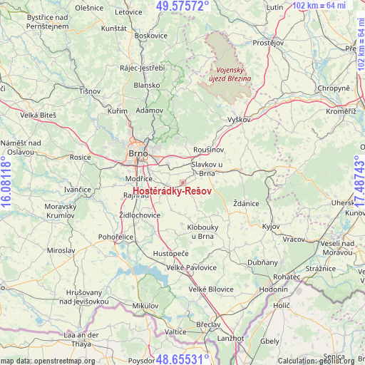
Hostěrádky-Rešov GPS coordinates[2]
49° 7' 3.54" North, 16° 47' 3.48" East
| Map corner | latitude | longitude |
|---|---|---|
| Upper-left | 49.57572°, | 16.08118° |
| Center: | 49.11765°, | 16.7843° |
| Lower-right: | 48.65531°, | 17.48743° |
| Map W x H: | 102.3×102.3 km | = 63.6×63.6mi |
| max Lat: | 51.01104° ⇑85.5% North |
| Hostěrádky-Rešov: | 49.11765° |
| min Lat: | ⇓14.5% South 48.60378° |
| min Long | Hostěrádky-Re | max Long |
| 12.17577° | 16.7843° | 18.82683° |
| W 70.9%⇐ | ⇒29.1% E |
Elevation
Elevation of Hostěrádky-Rešov is 200 m = 656 ft, and this is 152 m = 499 ft below average elevation for this country.
| Max E: |
901 m = 2956 ft | 90.4% |
| Avg. | 352 m = 1155 ft | |
| Hostěrádky-Rešov | 200 m = 656 ft | |
Min E: |
136 m = 446 ft | 9.6% |
See also: Czech Republic elevation on elevation.city.
Geographical zone
Hostěrádky-Rešov is located in North temperate zone (between Tropic of Cancer and the Arctic Circle). Distance of this North polar circle is 1939.8 km =1205.3 mi to North.| Distance of | km | miles | from Hostěrádky-Rešov |
|---|---|---|---|
| North Pole | 4545.7 | 2824.6 | to North |
| Arctic Circle | 1939.8 | 1205.3 | to North |
| Tropic Cancer | 2855.5 | 1774.3 | to South |
| Equator | 5461.4 | 3393.6 | to South |


Nearby cities:
15 places around Hostěrádky-Rešov: (largest is in red/bold)
• Blažovice
5.3 km =3.3 mi,  1°
1°
• Holubice
7 km =4.3 mi,  16°
16°
• Hrušky
3.8 km =2.4 mi,  70°
70°
• Jiříkovice
5.8 km =3.6 mi,  340°
340°
• Kobylnice
4.4 km =2.7 mi,  300°
300°
• Křenovice
4.3 km =2.7 mi,  50°
50°
• Milešovice
6.4 km =4 mi,  127°
127°
• Otnice
4.1 km =2.5 mi,  147°
147°
• Prace
2.9 km =1.8 mi,  332°
332°
• Sokolnice
4.6 km =2.9 mi,  264°
264°
• Telnice
5.2 km =3.2 mi,  250°
250°
• Vážany nad Litavou
5.4 km =3.4 mi,  76°
76°
• Šaratice
1.4 km =0.9 mi,  90°
90°
• Šlapanice
7 km =4.3 mi,  323°
323°
• Žatčany
4.9 km =3 mi,  228°
228°
Sources, notices
• [Note1] Compared only with cities in Czech Republic existing in our database
• [Src1] Map data: © OpenStreetMap contributors (CC-BY-SA)
• [Src2] Other city data from geonames.org with taken over terms of usage.
• [Src3] Geographical zone / Annual Mean Temperature by Robert A. Rohde @ Wikipedia
