Dětenice geodata
Dětenice (Královéhradecký kraj) is a populated place; located in Czech Republic in Europe/Prague (GMT+2) time zone. With population of 736 people, there are 1752 cities with bigger population in this country. Compared to other cities in Czech Republic, 86.4% of cities are located further ↓South; 59.3% of cities are located further →East and 81.3% of cities have higher elevation than Dětenice. Note1


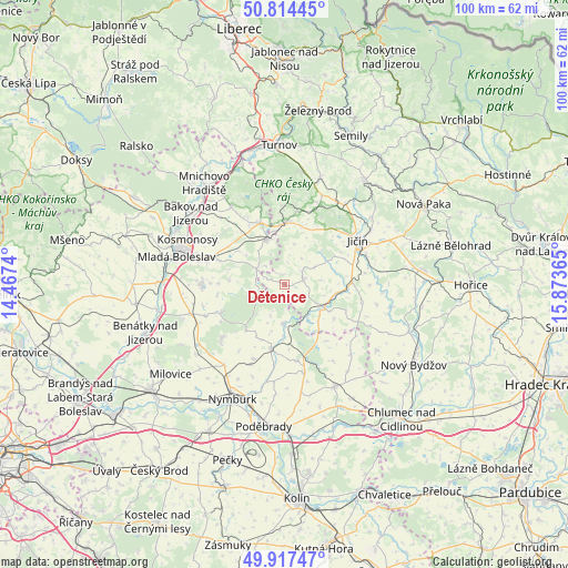
Dětenice GPS coordinates[2]
50° 22' 5.088" North, 15° 10' 13.872" East
| Map corner | latitude | longitude |
|---|---|---|
| Upper-left | 50.81445°, | 14.4674° |
| Center: | 50.36808°, | 15.17052° |
| Lower-right: | 49.91747°, | 15.87365° |
| Map W x H: | 99.7×99.7 km | = 62×62mi |
| max Lat: | 51.01104° ⇑13.6% North |
| Dětenice: | 50.36808° |
| min Lat: | ⇓86.4% South 48.60378° |
| min Long | Dětenice | max Long |
| 12.17577° | 15.17052° | 18.82683° |
| W 40.7%⇐ | ⇒59.3% E |
Elevation
Elevation of Dětenice is 227 m = 745 ft, and this is 125 m = 410 ft below average elevation for this country.
| Max E: |
901 m = 2956 ft | 81.3% |
| Avg. | 352 m = 1155 ft | |
| Dětenice | 227 m = 745 ft | |
Min E: |
136 m = 446 ft | 18.7% |
See also: Czech Republic elevation on elevation.city.
Geographical zone
Dětenice is located in North temperate zone (between Tropic of Cancer and the Arctic Circle). Distance of this North polar circle is 1800.8 km =1119 mi to North.| Distance of | km | miles | from Dětenice |
|---|---|---|---|
| North Pole | 4406.7 | 2738.2 | to North |
| Arctic Circle | 1800.8 | 1119 | to North |
| Tropic Cancer | 2994.5 | 1860.7 | to South |
| Equator | 5600.4 | 3479.9 | to South |


Nearby cities:
15 places around Dětenice: (largest is in red/bold)
• Březno
12.4 km =7.7 mi,  289°
289°
• Dobrovice
14.8 km =9.2 mi,  270°
270°
• Dolní Bousov
8.4 km =5.2 mi,  338°
338°
• Dymokury
13.8 km =8.6 mi,  170°
170°
• Holín
14.1 km =8.8 mi,  48°
48°
• Hrubý Jeseník
14.1 km =8.8 mi,  202°
202°
• Jičín
15 km =9.3 mi,  59°
59°
• Jičíněves
11.8 km =7.3 mi,  87°
87°
• Kopidlno
8.2 km =5.1 mi,  120°
120°
• Křinec
11.7 km =7.3 mi,  191°
191°
• Libáň
3.4 km =2.1 mi,  76°
76°
• Loučeň
14.1 km =8.8 mi,  229°
229°
• Rožďalovice
7 km =4.3 mi,  180°
180°
• Semčice
11.6 km =7.2 mi, 270°
• Sobotka
11.1 km =6.9 mi,  2°
2°
Sources, notices
• [Note1] Compared only with cities in Czech Republic existing in our database
• [Src1] Map data: © OpenStreetMap contributors (CC-BY-SA)
• [Src2] Other city data from geonames.org with taken over terms of usage.
• [Src3] Geographical zone / Annual Mean Temperature by Robert A. Rohde @ Wikipedia
