Dešná geodata
Dešná (Jihočeský kraj) is a populated place; located in Czech Republic in Europe/Prague (GMT+2) time zone. With population of 657 people, there are 1963 cities with bigger population in this country. Compared to other cities in Czech Republic, 93.5% of cities are located further ↑North; 52.4% of cities are located further →East and 80.1% of cities have lower elevation than Dešná. Note1


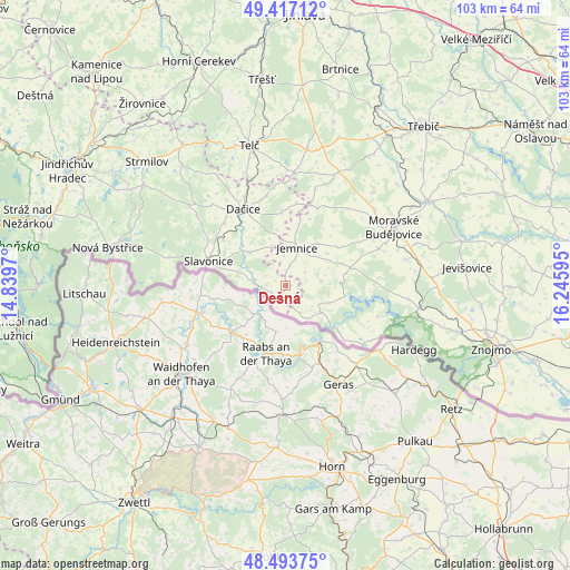
Dešná GPS coordinates[2]
48° 57' 27.252" North, 15° 32' 34.152" East
| Map corner | latitude | longitude |
|---|---|---|
| Upper-left | 49.41712°, | 14.8397° |
| Center: | 48.95757°, | 15.54282° |
| Lower-right: | 48.49375°, | 16.24595° |
| Map W x H: | 102.7×102.7 km | = 63.8×63.8mi |
| max Lat: | 51.01104° ⇑93.5% North |
| Dešná: | 48.95757° |
| min Lat: | ⇓6.5% South 48.60378° |
| min Long | Dešná | max Long |
| 12.17577° | 15.54282° | 18.82683° |
| W 47.6%⇐ | ⇒52.4% E |
Elevation
Elevation of Dešná is 465 m = 1526 ft, and this is 113 m = 371 ft above average elevation for this country.
| Max E: |
901 m = 2956 ft | 19.9% |
| Dešná | 465 m 1526 ft | |
| Avg. | 352 m = 1155 ft | |
Min E: |
136 m = 446 ft | 80.1% |
See also: Czech Republic elevation on elevation.city.
Geographical zone
Dešná is located in North temperate zone (between Tropic of Cancer and the Arctic Circle). Distance of this North polar circle is 1957.6 km =1216.4 mi to North.| Distance of | km | miles | from Dešná |
|---|---|---|---|
| North Pole | 4563.5 | 2835.6 | to North |
| Arctic Circle | 1957.6 | 1216.4 | to North |
| Tropic Cancer | 2837.7 | 1763.3 | to South |
| Equator | 5443.6 | 3382.5 | to South |


Nearby cities:
15 places around Dešná: (largest is in red/bold)
• Blížkovice
21.8 km =13.5 mi,  77°
77°
• Budíškovice
13.2 km =8.2 mi,  356°
356°
• Cizkrajov
13.8 km =8.6 mi,  305°
305°
• Dačice
15.8 km =9.8 mi,  330°
330°
• Jemnice
7.1 km =4.4 mi,  16°
16°
• Moravské Budějovice
22.1 km =13.7 mi,  61°
61°
• Nová Říše
20.3 km =12.6 mi,  4°
4°
• Nové Syrovice
18.1 km =11.2 mi,  68°
68°
• Písečné
5.9 km =3.7 mi,  277°
277°
• Slavonice
14.6 km =9.1 mi,  287°
287°
• Staré Hobzí
8.8 km =5.5 mi, 311°
• Volfířov
20.8 km =12.9 mi,  322°
322°
• Vranov
20.9 km =13 mi,  109°
109°
• Český Rudolec
20.1 km =12.5 mi, 307°
• Štítary
22.2 km =13.8 mi,  96°
96°
Sources, notices
• [Note1] Compared only with cities in Czech Republic existing in our database
• [Src1] Map data: © OpenStreetMap contributors (CC-BY-SA)
• [Src2] Other city data from geonames.org with taken over terms of usage.
• [Src3] Geographical zone / Annual Mean Temperature by Robert A. Rohde @ Wikipedia
