Dešenice geodata
Dešenice (Plzeňský kraj) is a populated place; located in Czech Republic in Europe/Prague (GMT+2) time zone. With population of 709 people, there are 1811 cities with bigger population in this country. Compared to other cities in Czech Republic, 77.7% of cities are located further ↑North; 95.1% of cities are located further →East and 86.1% of cities have lower elevation than Dešenice. Note1


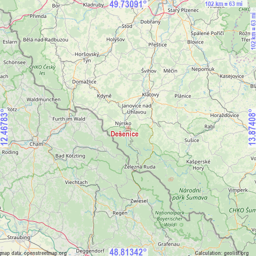
Dešenice GPS coordinates[2]
49° 16' 27.48" North, 13° 10' 15.42" East
| Map corner | latitude | longitude |
|---|---|---|
| Upper-left | 49.73091°, | 12.46783° |
| Center: | 49.2743°, | 13.17095° |
| Lower-right: | 48.81342°, | 13.87408° |
| Map W x H: | 102×102 km | = 63.4×63.4mi |
| max Lat: | 51.01104° ⇑77.7% North |
| Dešenice: | 49.2743° |
| min Lat: | ⇓22.3% South 48.60378° |
| min Long | Dešenice | max Long |
| 12.17577° | 13.17095° | 18.82683° |
| W 4.9%⇐ | ⇒95.1% E |
Elevation
Elevation of Dešenice is 502 m = 1647 ft, and this is 150 m = 492 ft above average elevation for this country.
| Max E: |
901 m = 2956 ft | 13.9% |
| Dešenice | 502 m 1647 ft | |
| Avg. | 352 m = 1155 ft | |
Min E: |
136 m = 446 ft | 86.1% |
See also: Czech Republic elevation on elevation.city.
Geographical zone
Dešenice is located in North temperate zone (between Tropic of Cancer and the Arctic Circle). Distance of this North polar circle is 1922.4 km =1194.5 mi to North.| Distance of | km | miles | from Dešenice |
|---|---|---|---|
| North Pole | 4528.3 | 2813.8 | to North |
| Arctic Circle | 1922.4 | 1194.5 | to North |
| Tropic Cancer | 2872.9 | 1785.1 | to South |
| Equator | 5478.8 | 3404.4 | to South |


Nearby cities:
15 places around Dešenice: (largest is in red/bold)
• Bezděkov
12.5 km =7.8 mi,  19°
19°
• Běšiny
10.7 km =6.6 mi,  73°
73°
• Chudenín
5.5 km =3.4 mi,  292°
292°
• Janovice nad Úhlavou
8.6 km =5.3 mi, 23°
• Kdyně
16.1 km =10 mi,  323°
323°
• Klatovy
16.2 km =10.1 mi,  33°
33°
• Mochtín
16.5 km =10.3 mi,  54°
54°
• Nýrsko
2.9 km =1.8 mi, 317°
• Pocinovice
8.2 km =5.1 mi,  340°
340°
• Strážov
6.3 km =3.9 mi,  59°
59°
• Velhartice
15.9 km =9.9 mi,  93°
93°
• Vrhaveč
12 km =7.5 mi, 48°
• Všeruby
15.5 km =9.6 mi,  298°
298°
• Čachrov
9.6 km =6 mi,  95°
95°
• Železná Ruda
15.9 km =9.9 mi,  162°
162°
Sources, notices
• [Note1] Compared only with cities in Czech Republic existing in our database
• [Src1] Map data: © OpenStreetMap contributors (CC-BY-SA)
• [Src2] Other city data from geonames.org with taken over terms of usage.
• [Src3] Geographical zone / Annual Mean Temperature by Robert A. Rohde @ Wikipedia
