Děčín geodata
Děčín (Ústecký kraj) is a populated place; located in Czech Republic in Europe/Prague (GMT+2) time zone. With population of 52,058 people, there are 17 cities with bigger population in this country. Compared to other cities in Czech Republic, 98.4% of cities are located further ↓South; 79.4% of cities are located further →East and 100% of cities have higher elevation than Děčín. Note1


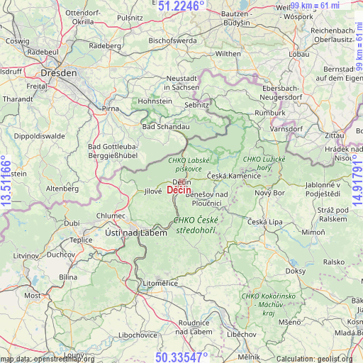
Děčín GPS coordinates[2]
50° 46' 55.74" North, 14° 12' 53.208" East
| Map corner | latitude | longitude |
|---|---|---|
| Upper-left | 51.2246°, | 13.51166° |
| Center: | 50.78215°, | 14.21478° |
| Lower-right: | 50.33547°, | 14.91791° |
| Map W x H: | 98.9×98.9 km | = 61.5×61.5mi |
| max Lat: | 51.01104° ⇑1.6% North |
| Děčín: | 50.78215° |
| min Lat: | ⇓98.4% South 48.60378° |
| min Long | Děčín | max Long |
| 12.17577° | 14.21478° | 18.82683° |
| W 20.6%⇐ | ⇒79.4% E |
Elevation
Elevation of Děčín is 138 m = 453 ft, and this is 214 m = 702 ft below average elevation for this country.
| Max E: |
901 m = 2956 ft | 100% |
| Avg. | 352 m = 1155 ft | |
| Děčín | 138 m = 453 ft | |
Min E: |
136 m = 446 ft | 0% |
See also: Děčín elevation on elevation.city.
Geographical zone
Děčín is located in North temperate zone (between Tropic of Cancer and the Arctic Circle). Distance of this North polar circle is 1754.7 km =1090.3 mi to North.| Distance of | km | miles | from Děčín |
|---|---|---|---|
| North Pole | 4360.6 | 2709.6 | to North |
| Arctic Circle | 1754.7 | 1090.3 | to North |
| Tropic Cancer | 3040.5 | 1889.3 | to South |
| Equator | 5646.4 | 3508.5 | to South |


Nearby cities:
15 places around Děčín: (largest is in red/bold)
• Benešov nad Ploučnicí
8.2 km =5.1 mi,  123°
123°
• Dobkovice
7.6 km =4.7 mi,  191°
191°
• Dolní Habartice
9.2 km =5.7 mi, 115°
• Huntířov
6.3 km =3.9 mi,  82°
82°
• Jílové
8.2 km =5.1 mi,  253°
253°
• Libouchec
12.5 km =7.8 mi,  257°
257°
• Ludvíkovice
3.2 km =2 mi,  65°
65°
• Malé Březno
12.5 km =7.8 mi, 193°
• Malšovice
6.1 km =3.8 mi,  211°
211°
• Markvartice
9.9 km =6.2 mi,  94°
94°
• Povrly
12.8 km =8 mi,  197°
197°
• Tisá
12.9 km =8 mi,  271°
271°
• Velké Březno
14.2 km =8.8 mi, 201°
• Velké Chvojno
13.7 km =8.5 mi, 245°
• Česká Kamenice
14.4 km =8.9 mi, 83°
Sources, notices
• [Note1] Compared only with cities in Czech Republic existing in our database
• [Src1] Map data: © OpenStreetMap contributors (CC-BY-SA)
• [Src2] Other city data from geonames.org with taken over terms of usage.
• [Src3] Geographical zone / Annual Mean Temperature by Robert A. Rohde @ Wikipedia
