Chvojenec geodata
Chvojenec (Pardubický) is a populated place; located in Czech Republic in Europe/Prague (GMT+2) time zone. With population of 619 people, there are 2069 cities with bigger population in this country. Compared to other cities in Czech Republic, 72.6% of cities are located further ↓South; 54.2% of cities are located further ←West and 74.2% of cities have higher elevation than Chvojenec. Note1


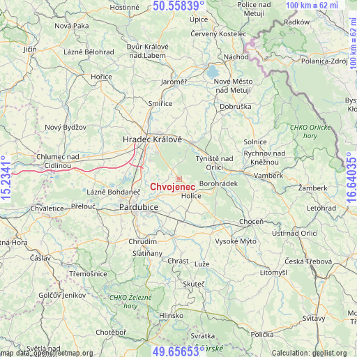
Chvojenec GPS coordinates[2]
50° 6' 34.488" North, 15° 56' 13.992" East
| Map corner | latitude | longitude |
|---|---|---|
| Upper-left | 50.55839°, | 15.2341° |
| Center: | 50.10958°, | 15.93722° |
| Lower-right: | 49.65653°, | 16.64035° |
| Map W x H: | 100.3×100.3 km | = 62.3×62.3mi |
| max Lat: | 51.01104° ⇑27.4% North |
| Chvojenec: | 50.10958° |
| min Lat: | ⇓72.6% South 48.60378° |
| min Long | Chvojenec | max Long |
| 12.17577° | 15.93722° | 18.82683° |
| W 54.2%⇐ | ⇒45.8% E |
Elevation
Elevation of Chvojenec is 246 m = 807 ft, and this is 106 m = 348 ft below average elevation for this country.
| Max E: |
901 m = 2956 ft | 74.2% |
| Avg. | 352 m = 1155 ft | |
| Chvojenec | 246 m = 807 ft | |
Min E: |
136 m = 446 ft | 25.8% |
See also: Czech Republic elevation on elevation.city.
Geographical zone
Chvojenec is located in North temperate zone (between Tropic of Cancer and the Arctic Circle). Distance of this North polar circle is 1829.5 km =1136.8 mi to North.| Distance of | km | miles | from Chvojenec |
|---|---|---|---|
| North Pole | 4435.4 | 2756 | to North |
| Arctic Circle | 1829.5 | 1136.8 | to North |
| Tropic Cancer | 2965.7 | 1842.8 | to South |
| Equator | 5571.7 | 3462.1 | to South |


Nearby cities:
15 places around Chvojenec: (largest is in red/bold)
• Albrechtice nad Orlicí
9.7 km =6 mi,  69°
69°
• Borohrádek
11.2 km =7 mi,  96°
96°
• Býšť
3.1 km =1.9 mi,  323°
323°
• Dašice
9.2 km =5.7 mi,  191°
191°
• Dolní Roveň
9.2 km =5.7 mi,  166°
166°
• Dolní Ředice
3.7 km =2.3 mi,  195°
195°
• Holice
6 km =3.7 mi,  144°
144°
• Horní Ředice
4 km =2.5 mi,  157°
157°
• Ostřetín
9.8 km =6.1 mi, 137°
• Rokytno
3.5 km =2.2 mi,  260°
260°
• Ráby
10.4 km =6.5 mi,  246°
246°
• Sezemice
7.7 km =4.8 mi,  231°
231°
• Týniště nad Orlicí
11 km =6.8 mi, 65°
• Třebechovice pod Orebem
10.9 km =6.8 mi,  21°
21°
• Vysoká nad Labem
9.4 km =5.8 mi,  301°
301°
Sources, notices
• [Note1] Compared only with cities in Czech Republic existing in our database
• [Src1] Map data: © OpenStreetMap contributors (CC-BY-SA)
• [Src2] Other city data from geonames.org with taken over terms of usage.
• [Src3] Geographical zone / Annual Mean Temperature by Robert A. Rohde @ Wikipedia
