Čechy pod Kosířem geodata
Čechy pod Kosířem (Olomoucký) is a populated place; located in Czech Republic in Europe/Prague (GMT+2) time zone. With population of 982 people, there are 1309 cities with bigger population in this country. Compared to other cities in Czech Republic, 62.8% of cities are located further ↑North; 76.6% of cities are located further ←West and 64.2% of cities have higher elevation than Čechy pod Kosířem. Note1


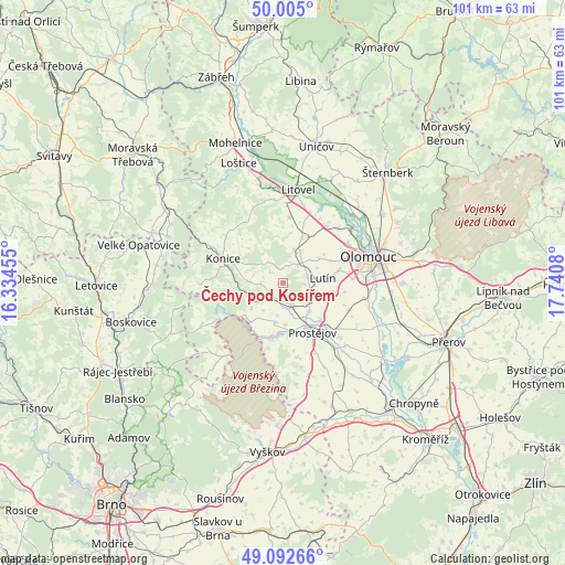
Čechy pod Kosířem GPS coordinates[2]
49° 33' 3.456" North, 17° 2' 15.612" East
| Map corner | latitude | longitude |
|---|---|---|
| Upper-left | 50.005°, | 16.33455° |
| Center: | 49.55096°, | 17.03767° |
| Lower-right: | 49.09266°, | 17.7408° |
| Map W x H: | 101.4×101.4 km | = 63×63mi |
| max Lat: | 51.01104° ⇑62.8% North |
| Čechy pod Kosířem: | 49.55096° |
| min Lat: | ⇓37.2% South 48.60378° |
| min Long | Čechy pod Kos� | max Long |
| 12.17577° | 17.03767° | 18.82683° |
| W 76.6%⇐ | ⇒23.4% E |
Elevation
Elevation of Čechy pod Kosířem is 277 m = 909 ft, and this is 75 m = 246 ft below average elevation for this country.
| Max E: |
901 m = 2956 ft | 64.2% |
| Avg. | 352 m = 1155 ft | |
| Čechy pod Kosířem | 277 m = 909 ft | |
Min E: |
136 m = 446 ft | 35.8% |
See also: Czech Republic elevation on elevation.city.
Geographical zone
Čechy pod Kosířem is located in North temperate zone (between Tropic of Cancer and the Arctic Circle). Distance of this North polar circle is 1891.6 km =1175.4 mi to North.| Distance of | km | miles | from Čechy pod Kosířem |
|---|---|---|---|
| North Pole | 4497.5 | 2794.6 | to North |
| Arctic Circle | 1891.6 | 1175.4 | to North |
| Tropic Cancer | 2903.6 | 1804.2 | to South |
| Equator | 5509.6 | 3423.5 | to South |


Nearby cities:
15 places around Čechy pod Kosířem: (largest is in red/bold)
• Drahanovice
4.2 km =2.6 mi,  42°
42°
• Kostelec na Hané
4.4 km =2.7 mi,  160°
160°
• Laškov
4.5 km =2.8 mi,  325°
325°
• Loučany
6.5 km =4 mi,  29°
29°
• Lutín
7.1 km =4.4 mi,  83°
83°
• Náměšť na Hané
6 km =3.7 mi,  19°
19°
• Ptení
7 km =4.3 mi,  231°
231°
• Pěnčín
2.5 km =1.6 mi,  315°
315°
• Přemyslovice
5.9 km =3.7 mi,  275°
275°
• Senice na Hané
8.8 km =5.5 mi, 23°
• Slatinice
4.6 km =2.9 mi, 75°
• Smržice
7.1 km =4.4 mi,  135°
135°
• Stařechovice
2.3 km =1.4 mi,  150°
150°
• Těšetice
7.9 km =4.9 mi,  53°
53°
• Čelechovice na Hané
5.6 km =3.5 mi,  133°
133°
Sources, notices
• [Note1] Compared only with cities in Czech Republic existing in our database
• [Src1] Map data: © OpenStreetMap contributors (CC-BY-SA)
• [Src2] Other city data from geonames.org with taken over terms of usage.
• [Src3] Geographical zone / Annual Mean Temperature by Robert A. Rohde @ Wikipedia
