Bystřice nad Pernštejnem geodata
Bystřice nad Pernštejnem (Vysočina) is a populated place; located in Czech Republic in Europe/Prague (GMT+2) time zone. With population of 8,996 people, there are 160 cities with bigger population in this country. Compared to other cities in Czech Republic, 64.7% of cities are located further ↑North; 60.2% of cities are located further ←West and 90.6% of cities have lower elevation than Bystřice nad Pernštejnem. Note1
Administrative division(s):
- Level 1: Vysočina
- Level 2: Okres Žďár nad Sázavou
- Level 3: Bystřice nad Pernštejnem
Current local time in Bystřice nad Pernštejnem:
04:48 AM, SaturdayDifference from your time zone: hours


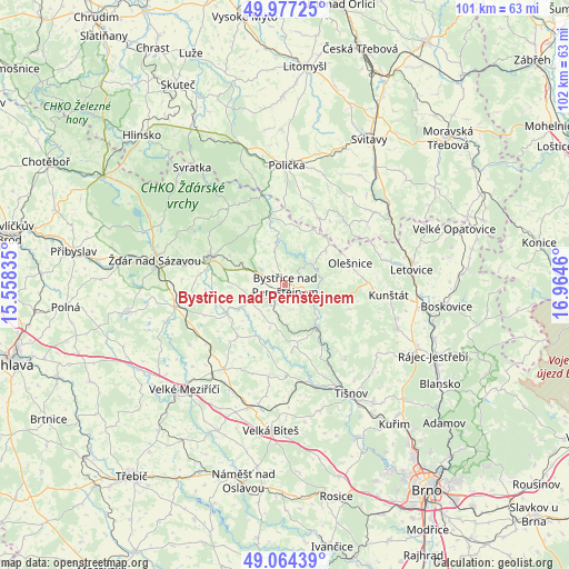
Bystřice nad Pernštejnem GPS coordinates[2]
49° 31' 22.62" North, 16° 15' 41.292" East
| Map corner | latitude | longitude |
|---|---|---|
| Upper-left | 49.97725°, | 15.55835° |
| Center: | 49.52295°, | 16.26147° |
| Lower-right: | 49.06439°, | 16.9646° |
| Map W x H: | 101.5×101.5 km | = 63.1×63.1mi |
| max Lat: | 51.01104° ⇑64.7% North |
| Bystřice nad Pernštejnem: | 49.52295° |
| min Lat: | ⇓35.3% South 48.60378° |
| min Long | Bystřice nad P | max Long |
| 12.17577° | 16.26147° | 18.82683° |
| W 60.2%⇐ | ⇒39.8% E |
Elevation
Elevation of Bystřice nad Pernštejnem is 534 m = 1752 ft, and this is 182 m = 597 ft above average elevation for this country.
| Max E: |
901 m = 2956 ft | 9.4% |
| Bystřice nad Pernštejnem | 534 m 1752 ft | |
| Avg. | 352 m = 1155 ft | |
Min E: |
136 m = 446 ft | 90.6% |
See also: Czech Republic elevation on elevation.city.
Geographical zone
Bystřice nad Pernštejnem is located in North temperate zone (between Tropic of Cancer and the Arctic Circle). Distance of this North polar circle is 1894.7 km =1177.3 mi to North.| Distance of | km | miles | from Bystřice nad Pernštejnem |
|---|---|---|---|
| North Pole | 4500.6 | 2796.5 | to North |
| Arctic Circle | 1894.7 | 1177.3 | to North |
| Tropic Cancer | 2900.5 | 1802.3 | to South |
| Equator | 5506.4 | 3421.5 | to South |


Nearby cities:
15 places around Bystřice nad Pernštejnem: (largest is in red/bold)
• Dalečín
7.8 km =4.8 mi,  348°
348°
• Dolní Rožínka
6.3 km =3.9 mi,  215°
215°
• Doubravník
12.8 km =8 mi,  149°
149°
• Jimramov
13 km =8.1 mi, 348°
• Moravec
12.6 km =7.8 mi, 222°
• Nedvědice
9 km =5.6 mi,  144°
144°
• Olešnice
12.2 km =7.6 mi,  71°
71°
• Radešínská Svratka
12.8 km =8 mi,  262°
262°
• Rovečné
9.5 km =5.9 mi,  50°
50°
• Rozsochy
4.4 km =2.7 mi, 264°
• Rožná
5.3 km =3.3 mi,  198°
198°
• Strážek
10.4 km =6.5 mi,  208°
208°
• Vír
5.9 km =3.7 mi, 49°
• Věcov
12.3 km =7.6 mi,  327°
327°
• Zvole
7 km =4.3 mi,  243°
243°
Sources, notices
• [Note1] Compared only with cities in Czech Republic existing in our database
• [Src1] Map data: © OpenStreetMap contributors (CC-BY-SA)
• [Src2] Other city data from geonames.org with taken over terms of usage.
• [Src3] Geographical zone / Annual Mean Temperature by Robert A. Rohde @ Wikipedia
