Brodek u Přerova geodata
Brodek u Přerova (Olomoucký) is a populated place; located in Czech Republic in Europe/Prague (GMT+2) time zone. With population of 1,972 people, there are 648 cities with bigger population in this country. Compared to other cities in Czech Republic, 66.5% of cities are located further ↑North; 82.3% of cities are located further ←West and 88% of cities have higher elevation than Brodek u Přerova. Note1


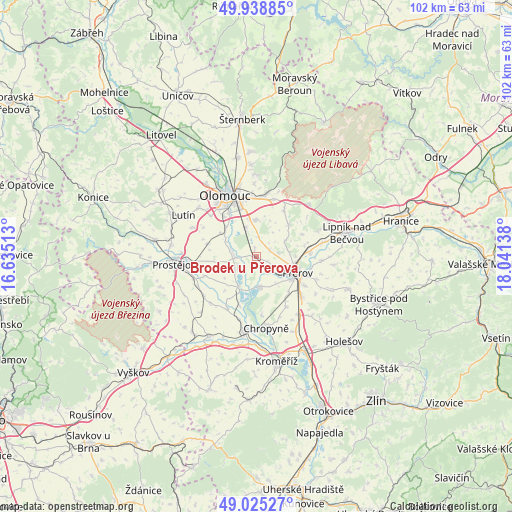
Brodek u Přerova GPS coordinates[2]
49° 29' 3.084" North, 17° 20' 17.7" East
| Map corner | latitude | longitude |
|---|---|---|
| Upper-left | 49.93885°, | 16.63513° |
| Center: | 49.48419°, | 17.33825° |
| Lower-right: | 49.02527°, | 18.04138° |
| Map W x H: | 101.6×101.6 km | = 63.1×63.1mi |
| max Lat: | 51.01104° ⇑66.5% North |
| Brodek u Přerova: | 49.48419° |
| min Lat: | ⇓33.5% South 48.60378° |
| min Long | Brodek u Přero | max Long |
| 12.17577° | 17.33825° | 18.82683° |
| W 82.3%⇐ | ⇒17.7% E |
Elevation
Elevation of Brodek u Přerova is 207 m = 679 ft, and this is 145 m = 476 ft below average elevation for this country.
| Max E: |
901 m = 2956 ft | 88% |
| Avg. | 352 m = 1155 ft | |
| Brodek u Přerova | 207 m = 679 ft | |
Min E: |
136 m = 446 ft | 12% |
See also: Czech Republic elevation on elevation.city.
Geographical zone
Brodek u Přerova is located in North temperate zone (between Tropic of Cancer and the Arctic Circle). Distance of this North polar circle is 1899 km =1180 mi to North.| Distance of | km | miles | from Brodek u Přerova |
|---|---|---|---|
| North Pole | 4504.9 | 2799.2 | to North |
| Arctic Circle | 1899 | 1180 | to North |
| Tropic Cancer | 2896.2 | 1799.6 | to South |
| Equator | 5502.1 | 3418.8 | to South |


Nearby cities:
15 places around Brodek u Přerova: (largest is in red/bold)
• Blatec
8.7 km =5.4 mi,  304°
304°
• Bochoř
9.5 km =5.9 mi,  136°
136°
• Charváty
7.2 km =4.5 mi, 301°
• Citov
2.1 km =1.3 mi,  206°
206°
• Dub nad Moravou
4.4 km =2.7 mi,  267°
267°
• Grygov
6.4 km =4 mi,  340°
340°
• Kokory
2.9 km =1.8 mi,  66°
66°
• Majetín
1.6 km =1 mi,  346°
346°
• Přerov
8.8 km =5.5 mi,  111°
111°
• Rokytnice
4.3 km =2.7 mi,  117°
117°
• Tovačov
7 km =4.3 mi, 211°
• Troubky
5.8 km =3.6 mi,  172°
172°
• Tršice
9 km =5.6 mi,  44°
44°
• Velký Týnec
7.3 km =4.5 mi,  357°
357°
• Věrovany
4.5 km =2.8 mi,  234°
234°
Sources, notices
• [Note1] Compared only with cities in Czech Republic existing in our database
• [Src1] Map data: © OpenStreetMap contributors (CC-BY-SA)
• [Src2] Other city data from geonames.org with taken over terms of usage.
• [Src3] Geographical zone / Annual Mean Temperature by Robert A. Rohde @ Wikipedia
