Brno geodata
Brno (South Moravian) is a seat of a first-order administrative division; located in Czech Republic in Europe/Prague (GMT+2) time zone. With population of 369,559 people, there is 1 city with bigger population in this country. Compared to other cities in Czech Republic, 81.3% of cities are located further ↑North; 67% of cities are located further ←West and 81.7% of cities have higher elevation than Brno. Note1


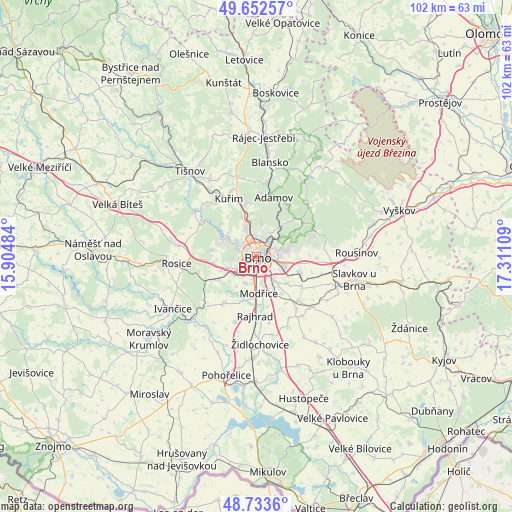
Brno GPS coordinates[2]
49° 11' 42.792" North, 16° 36' 28.656" East
| Map corner | latitude | longitude |
|---|---|---|
| Upper-left | 49.65257°, | 15.90484° |
| Center: | 49.19522°, | 16.60796° |
| Lower-right: | 48.7336°, | 17.31109° |
| Map W x H: | 102.2×102.2 km | = 63.5×63.5mi |
| max Lat: | 51.01104° ⇑81.3% North |
| Brno: | 49.19522° |
| min Lat: | ⇓18.7% South 48.60378° |
| min Long | Brno | max Long |
| 12.17577° | 16.60796° | 18.82683° |
| W 67%⇐ | ⇒33% E |
Elevation
Elevation of Brno is 226 m = 741 ft, and this is 126 m = 413 ft below average elevation for this country.
| Max E: |
901 m = 2956 ft | 81.7% |
| Avg. | 352 m = 1155 ft | |
| Brno | 226 m = 741 ft | |
Min E: |
136 m = 446 ft | 18.3% |
See also: Brno elevation on elevation.city.
Geographical zone
Brno is located in North temperate zone (between Tropic of Cancer and the Arctic Circle). Distance of this North polar circle is 1931.2 km =1200 mi to North.| Distance of | km | miles | from Brno |
|---|---|---|---|
| North Pole | 4537.1 | 2819.2 | to North |
| Arctic Circle | 1931.2 | 1200 | to North |
| Tropic Cancer | 2864.1 | 1779.7 | to South |
| Equator | 5470 | 3398.9 | to South |


Nearby cities:
15 places around Brno: (largest is in red/bold)
• Bílovice nad Svitavou
7.4 km =4.6 mi,  39°
39°
• Jinačovice
10 km =6.2 mi,  324°
324°
• Modřice
8.4 km =5.2 mi,  181°
181°
• Mokrá Hora
7.5 km =4.7 mi,  350°
350°
• Moravany
5.6 km =3.5 mi,  200°
200°
• Ostopovice
5.9 km =3.7 mi,  230°
230°
• Podolí
8.2 km =5.1 mi,  93°
93°
• Popůvky
9 km =5.6 mi,  257°
257°
• Rozdrojovice
9.7 km =6 mi,  312°
312°
• Střelice
8.9 km =5.5 mi,  237°
237°
• Troubsko
7.6 km =4.7 mi,  247°
247°
• Česká
9.9 km =6.2 mi,  341°
341°
• Řícmanice
9.3 km =5.8 mi, 42°
• Šlapanice
9.2 km =5.7 mi,  108°
108°
• Želešice
8.9 km =5.5 mi,  192°
192°
Sources, notices
• [Note1] Compared only with cities in Czech Republic existing in our database
• [Src1] Map data: © OpenStreetMap contributors (CC-BY-SA)
• [Src2] Other city data from geonames.org with taken over terms of usage.
• [Src3] Geographical zone / Annual Mean Temperature by Robert A. Rohde @ Wikipedia
